

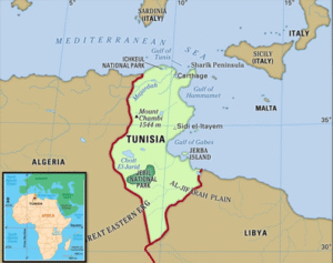
Location and Borders
-
Africa’s northernmost nation
-
Shares a northern and eastern border with the Mediterranean Sea
-
Neighbouring countries:
-
Algeria in the west
-
Libya in the southeast
-
Capital
-
Tunisia
Groups by Ethnicity
-
98% Arab
-
European: 1%
-
Minorities, including Jews: 1%
The Economy
-
Categorised as lower middle-income
-
High rates of unemployment, particularly for women and young people
-
Depends on:
-
Phosphates
-
Petroleum
-
Tourism
-
Agriculture
-
The Act of Terrorism
-
Existence of the network of Islamic State of Iraq and Ash-Sham (ISIS)
-
Ajnad al-Khilafah (Army of the Caliphate) is the local name for it
Relations with Other Countries
-
United Nations (UN) member
-
Islamic Cooperation Organisation (OIC)
-
The African Union (AU)
-
Movement Non-Aligned (NAM)
-
Group 77 (G-77)
Key Physical Characteristics
-
Atlas Mountains: The Dorsal Range spans the northwest
-
Sahara Desert: Covers southern Tunisia
-
Chotts (Salt Lakes): Largest is Chott el Jerid in the southwest
-
Cape Angela: Northernmost point of Africa, located in Tunisia
-
Coastline: Long Mediterranean coast with fertile plains in the north and east
ट्यूनीशिया:
स्थान और सीमाएँ
-
अफ्रीका का उत्तरीतम देश
-
उत्तर और पूर्व में भूमध्य सागर की सीमा
-
पड़ोसी देश:
-
पश्चिम में अल्जीरिया
-
दक्षिण-पूर्व में लीबिया
-
राजधानी
-
ट्यूनीशिया
जातीय समूह
-
98% अरब
-
यूरोपीय: 1%
-
अल्पसंख्यक, जिनमें यहूदी शामिल: 1%
अर्थव्यवस्था
-
निम्न मध्य-आय वर्गीकृत
-
उच्च बेरोजगारी दर, विशेषकर महिलाओं और युवाओं में
-
निर्भर करता है:
-
फॉस्फेट
-
पेट्रोलियम
-
पर्यटन
-
कृषि
-
आतंकवाद की स्थिति
-
इराक और शाम का इस्लामिक स्टेट (ISIS) नेटवर्क मौजूद
-
अजनाद अल-खिलाफ़ा (खिलाफ़त की सेना) इसका स्थानीय नाम है
अन्य देशों से संबंध
-
संयुक्त राष्ट्र (UN) का सदस्य
-
इस्लामिक कोऑपरेशन ऑर्गनाइजेशन (OIC)
-
अफ्रीकी संघ (AU)
-
गुट निरपेक्ष आंदोलन (NAM)
-
ग्रुप 77 (G-77)
प्रमुख भौतिक विशेषताएँ
-
एटलस पर्वतमाला: डॉर्सल रेंज उत्तर-पश्चिम में फैली है
-
सहारा रेगिस्तान: दक्षिणी ट्यूनीशिया को ढकता है
-
शॉट्स (नमक झीलें): सबसे बड़ी शॉट एल जेरीड, दक्षिण-पश्चिम में
-
केप एंजेला: अफ्रीका का उत्तरीतम बिंदु, ट्यूनीशिया में स्थित
-
तटरेखा: लंबी भूमध्यसागरीय तटरेखा, उत्तर और पूर्व में उपजाऊ मैदानों के साथ

