

Why in the News?
-
Recently, a powerful earthquake with a magnitude of 6.7 occurred off the coast of the Tanimbar Islands region of Indonesia.
-
The fact that the earthquake happened in an area with high seismic activity highlights Southeast Asia’s continuous tectonic instability.
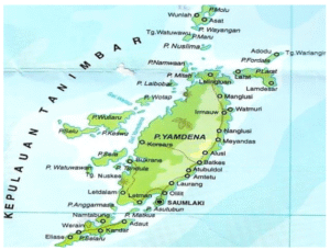
Concerning the Tanimbar Islands
-
Where
-
-
Situated in Indonesia’s Maluku province
-
Located at the southeast tip of the island chain that runs from Sumatra to Java, Bali, Lombok, and Timor
-
Positioned between the Arafura Sea in the south and the Banda Sea in the north
-
-
Geographical
-
-
A collection of about thirty islands that make up the Kei Archipelago
-
Belongs to the Regency of Southeast Maluku
-
-
Yamdena Island
-
-
The group’s largest island
-
At its broadest, it is about 70 miles long and 40 miles wide
-
-
Terrain and Vegetation
-
-
Eastern coast: covered with hills that are heavily forested
-
Western coast: lower in altitude and frequently swampy
-
Indonesian Seismic Activity
-
Indonesia is located in the Pacific Ring of Fire, an area known for its high levels of volcanic and seismic activity
-
It is the meeting point of several tectonic plates, which shift regularly
-
This tectonic environment makes Indonesia extremely vulnerable to earthquakes and volcanic eruptions
तनिम्बर द्वीपसमूह:
क्यों चर्चा में है
-
हाल ही में इंडोनेशिया के तनिम्बर द्वीपसमूह क्षेत्र के तट से दूर 6.7 तीव्रता का एक शक्तिशाली भूकंप आया।
-
यह तथ्य कि भूकंप एक उच्च भूकंपीय गतिविधि वाले क्षेत्र में हुआ, दक्षिण-पूर्व एशिया की निरंतर विवर्तनिक अस्थिरता को उजागर करता है।
तनिम्बर द्वीपसमूह के बारे में
-
स्थान
-
-
इंडोनेशिया के मलुकु प्रांत में स्थित
-
सुमात्रा से जावा, बाली, लोम्बोक और तिमोर तक फैली द्वीप श्रृंखला के दक्षिण-पूर्वी सिरे पर स्थित
-
दक्षिण में अराफुरा सागर और उत्तर में बांदा सागर के बीच स्थित
-
-
भौगोलिक स्थिति
-
-
केई द्वीपसमूह का हिस्सा बनने वाले लगभग तीस द्वीपों का एक समूह
-
दक्षिण-पूर्व मलुकु रीजेंसी का हिस्सा
-
-
यमडेना द्वीप
-
-
इस समूह का सबसे बड़ा द्वीप
-
इसकी अधिकतम लंबाई लगभग 70 मील और चौड़ाई लगभग 40 मील है
-
-
प्राकृतिक भू-आकृति और वनस्पति
-
-
पूर्वी तट: पहाड़ियों से आच्छादित, जो घने जंगलों से ढकी हैं
-
पश्चिमी तट: ऊंचाई में कम और अक्सर दलदली होता है
-
इंडोनेशिया की भूकंपीय गतिविधि
-
इंडोनेशिया प्रशांत रिंग ऑफ फायर में स्थित है, जो ज्वालामुखीय और भूकंपीय गतिविधियों के उच्च स्तर के लिए जाना जाता है
-
यह कई विवर्तनिक प्लेटों का मिलन बिंदु है, जो नियमित रूप से खिसकती रहती हैं
-
यह विवर्तनिक वातावरण इंडोनेशिया को भूकंपों और ज्वालामुखी विस्फोटों के लिए अत्यधिक संवेदनशील बनाता है |

