
Balasore district, located in Odisha, experienced severe flooding.
The flooding occurred due to the release of water from the Chandil Dam.
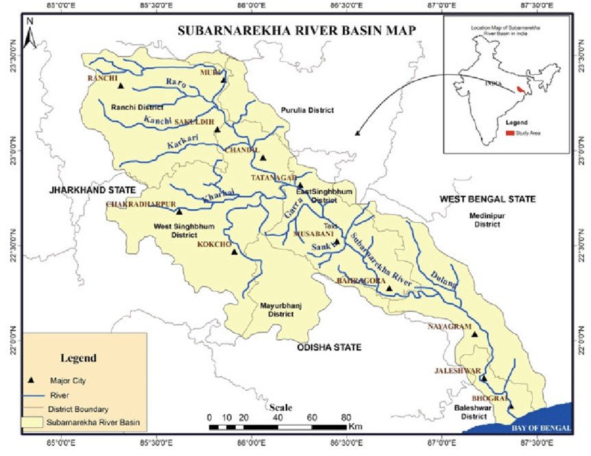
Chandil Dam is constructed across the Subarnarekha River in Jharkhand.
Odisha authorities alleged that the water was released without prior intimation.
The incident raised inter-state concerns between Jharkhand and Odisha regarding dam water management.
Subarnarekha River originates near Nagri village in Ranchi district, Jharkhand.
The river flows through Jharkhand, West Bengal, and Odisha before draining into the Bay of Bengal.
Its total length is approximately 395 kilometers, and it forms an estuary at its mouth.
The river’s drainage area is about 19,500 sq. km, covering three eastern Indian states.
Major right bank tributary is the Kharkai River, joining near Jamshedpur in Jharkhand.
Other tributaries include Kanchi, Raru, Karkari, Dulung, and Chandria Rivers.
The Chandil Dam is a key dam built under the Subarnarekha Multipurpose Project.
Galudih Barrage is constructed downstream for irrigation and water regulation.
The Subarnarekha Multipurpose Project is a joint venture of Jharkhand, Odisha, and West Bengal.
This project was designed for irrigation, hydroelectric power, and flood control.
The name “Subarnarekha” means “Streak of Gold” due to historic traces of gold in river sands.
Gold panning was once reported near its origin in Chota Nagpur Plateau region.
The river supports tribal communities and agricultural livelihoods in rural belts.
It is rain-fed, with flow highly dependent on monsoon rains and prone to flooding.
In June 2025, Balasore in Odisha was flooded due to alleged unnotified water release from Chandil Dam.
The flood highlighted inter-state coordination issues between Jharkhand and Odisha.
The river passes near Jamshedpur, an industrial city, receiving urban and industrial effluents.
The river has faced pollution issues due to industrial waste from mining and steel plants.
Despite pollution, the river is crucial for fisheries, groundwater recharge, and riparian ecology.
Environmental concerns persist due to unregulated sand mining and riverbank erosion.
सुवर्णरेखा नदी:-
ओडिशा का बालासोर जिला भीषण बाढ़ की चपेट में आ गया।
यह बाढ़ झारखंड में स्थित सुबर्णरेखा नदी पर बने चांडिल डैम से पानी छोड़े जाने के कारण आई।
बताया गया कि चांडिल डैम से बिना पूर्व सूचना के ओडिशा की ओर पानी छोड़ा गया।
इस घटना को लेकर झारखंड और ओडिशा के बीच अंतर-राज्यीय विवाद की स्थिति बनी।
सुबर्णरेखा नदी की उत्पत्ति रांची जिले के नगरी गाँव के पास झारखंड में होती है।
यह नदी झारखंड, पश्चिम बंगाल और ओडिशा से होकर बहती है और बंगाल की खाड़ी में गिरती है।
इसकी कुल लंबाई लगभग 395 किलोमीटर है और यह मुहाना (estuary) बनाती है।
इसका जलग्रहण क्षेत्र लगभग 19,500 वर्ग किलोमीटर है, जो तीन राज्यों में फैला है।
इसका प्रमुख दाहिना सहायक नदी है खरकई, जो जमशेदपुर के पास मिलती है।
अन्य सहायक नदियाँ हैं कांशी, रारू, कर्करी, डुलुंग और चंद्रिया।
चांडिल डैम इस नदी पर बना एक प्रमुख बहुउद्देश्यीय बांध है।
गलूडीह बैराज सिंचाई और जल नियंत्रण के लिए नीचे की ओर स्थित है।
सुबर्णरेखा बहुउद्देश्यीय परियोजना एक संयुक्त प्रयास है झारखंड, ओडिशा और पश्चिम बंगाल का।
यह परियोजना सिंचाई, जलविद्युत उत्पादन और बाढ़ नियंत्रण के लिए बनाई गई है।
“सुबर्णरेखा” का अर्थ है “सोने की रेखा” क्योंकि इसकी रेत में सोने के कण मिलते थे।
छोटा नागपुर पठार क्षेत्र में इसके उद्गम स्थल के पास सोना निकालने की परंपरा थी।
यह नदी जनजातीय समुदायों और कृषि आधारित आजीविका को समर्थन देती है।
यह एक वर्षा आधारित नदी है, जिसका प्रवाह मानसून पर निर्भर करता है और यह बाढ़ संभावित है।
जून 2025 में ओडिशा के बालासोर में चांडिल डैम से बिना सूचना जल छोड़ने के कारण बाढ़ आई।
इस बाढ़ ने झारखंड और ओडिशा के बीच अंतर-राज्यीय समन्वय की कमी को उजागर किया।
यह नदी जमशेदपुर जैसे औद्योगिक शहर के पास बहती है और उद्योगों का अपशिष्ट इसमें जाता है।
नदी को खनन और स्टील संयंत्रों से निकलने वाले प्रदूषण का सामना करना पड़ता है।
इसके बावजूद, यह नदी मछली पालन, भूजल पुनर्भरण और तटीय पारिस्थितिकी के लिए महत्वपूर्ण है।
अनियंत्रित बालू खनन और कटाव के कारण इसमें पर्यावरणीय समस्याएँ उत्पन्न हो रही हैं।

 Mon - Fri: 09:00 - 20:00 Sat & Sun : 10:30 - 18:00

