

Background
-
Due to nearby wildfires in Çanakkale, the Dardanelles Strait in northwest Turkey was temporarily closed to marine traffic.
-
Firefighting and evacuation efforts are in progress.
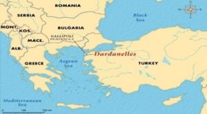
The Strait of Dardanelles
What it is
-
A slender, organic waterway that connects the Sea of Marmara and the Aegean Sea.
-
Known as the Hellespont in the past.
-
A vital military and commercial route since antiquity.
Where located
-
Located in Turkey’s northwest.
-
Divides Asia Minor (southeast) from Europe’s Gallipoli Peninsula (northwest).
-
Lies entirely inside the territorial waters of Turkey.
Qualities
-
About 61 kilometres in length.
-
Width ranges from 1.2 km to 6.5 km.
-
Average depth is about 55 meters, with the deepest point in the central narrow sections being about 90 meters.
-
Presents:
-
The Aegean Sea receives surface current from the Sea of Marmara.
-
The undercurrent carries saline water from the Aegean towards the Sea of Marmara.
-
Ports & Settlements
-
Key locations include Gallipoli, Eceabat, and Çanakkale.
Historical Significance
Battleground in major historical conflicts
-
Persian invasion (480 BCE).
-
Alexander the Great’s expedition (334 BCE).
-
World War I Gallipoli Campaign.
Implications of Closure
Global Trade
-
Disrupts shipping routes between Europe, Asia, and the Black Sea via the Bosporus.
Geopolitical Importance
-
Serves as a maritime chokepoint.
-
Crucial for Turkey’s strategic influence.
-
Important for NATO security interests.
दार्डानेल्स जलडमरूमध्य:
पृष्ठभूमि
-
चानाक्कले में पास के जंगलों में लगी आग के कारण, उत्तर-पश्चिम तुर्की में दार्डानेल्स जलडमरूमध्य को अस्थायी रूप से समुद्री यातायात के लिए बंद कर दिया गया।
-
अग्निशमन और निकासी के प्रयास जारी हैं।
दार्डानेल्स जलडमरूमध्य के बारे में
क्या है
-
एक पतला, प्राकृतिक जलमार्ग जो मरमरा सागर और एजियन सागर को जोड़ता है।
-
प्राचीन समय में हेल्सपॉन्ट के नाम से जाना जाता था।
-
प्राचीन काल से एक महत्वपूर्ण सैन्य और वाणिज्यिक मार्ग रहा है।
कहाँ स्थित है
-
तुर्की के उत्तर-पश्चिम में स्थित है।
-
एशिया माइनर (दक्षिण-पूर्व) को यूरोप के गैलीपोली प्रायद्वीप (उत्तर-पश्चिम) से अलग करता है।
-
पूरी तरह से तुर्की के क्षेत्रीय जल में स्थित है।
विशेषताएं
-
लगभग 61 किलोमीटर लंबा।
-
चौड़ाई 1.2 किलोमीटर से 6.5 किलोमीटर तक।
-
औसत गहराई लगभग 55 मीटर, जबकि मध्य के संकरे हिस्सों में सबसे गहरा बिंदु लगभग 90 मीटर है।
-
धाराएं:
-
एजियन सागर को मरमरा सागर से सतही धारा प्राप्त होती है।
-
भूमिगत धारा एजियन से खारा पानी मरमरा सागर की ओर ले जाती है।
-
बंदरगाह और बस्तियां
-
मुख्य स्थानों में गैलीपोली, एचेआबट और चानाक्कले शामिल हैं।
ऐतिहासिक महत्व
प्रमुख ऐतिहासिक संघर्षों में युद्धभूमि
-
फारसी आक्रमण (480 ईसा पूर्व)।
-
सिकंदर महान का अभियान (334 ईसा पूर्व)।
-
प्रथम विश्व युद्ध का गैलीपोली अभियान।
बंद होने के प्रभाव
वैश्विक व्यापार
-
यूरोप, एशिया और काला सागर के बीच, बॉस्फोरस के माध्यम से शिपिंग मार्गों में बाधा।
भू-राजनीतिक महत्व
-
एक समुद्री संकीर्ण मार्ग (चोकपॉइंट) के रूप में कार्य करता है।
-
तुर्की के रणनीतिक प्रभाव के लिए महत्वपूर्ण।
-
नाटो की सुरक्षा हितों के लिए महत्वपूर्ण।

