Why in the News?
-
In the midst of escalating regional tensions, India and the Philippines demonstrated their growing maritime cooperation
-
Conducted their first-ever bilateral joint naval drill in the South China Sea
The Naval Exercise between India and the Philippines
-
Goal
-
-
Bolster the two navies’ maritime cooperation and interoperability
-
Maintain the right to travel freely in disputed waters
-
-
Where
-
-
Held over two days in the South China Sea’s Philippine Exclusive Economic Zone (EEZ)
-
-
Deployed Indian Naval Assets
-
-
The guided missile destroyer INS Delhi
-
The fleet tanker INS Shakti
-
The anti-submarine warfare corvette INS Kiltan
-
-
Importance
-
-
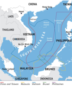
Symbolically refutes China’s nine-dash line claim
-
Strengthens the “Necklace of Diamonds” plan and India’s Act East Policy
-
Encourages freedom of navigation operations (FONOPs) and strengthens defence diplomacy
-
The South China Sea
-
What is it?
-
-
One of the western seas’ marginal Pacific Ocean
-
One of the world’s busiest and most disputed maritime regions
-
-
Location
-
-
Lies south of mainland China
-
Stretches from the Taiwan Strait (northeast) to the Strait of Malacca (southwest)
-
-
Neighbouring Nations
-
-
China
-
Taiwan
-
Philippines
-
Vietnam
-
Malaysia
-
Brunei
-
Indonesia
-
-
Region is marked by overlapping EEZ claims
-
-
Notably China’s Nine-Dash Line
-
-
Physical Features
-
-
Area: ~3.68 million sq. km
-
Maximum Depth: 5,016 m (China Sea Basin)
-
-
Key Islands/Shoals
-
-
Paracel Islands
-
Spratly Islands
-
Macclesfield Bank
-
Scarborough Shoal
-
-
Major Rivers Draining into the Sea
-
-
Pearl River (China)
-
Red River (Vietnam)
-
Mekong River (Vietnam)
-
दक्षिण चीन सागर:
समाचार में क्यों?
-
क्षेत्रीय तनाव के बीच, भारत और फिलीपींस ने अपने समुद्री सहयोग को बढ़ाते हुए
-
दक्षिण चीन सागर में पहली द्विपक्षीय संयुक्त नौसैनिक अभ्यास किया
भारत और फिलीपींस के बीच नौसैनिक अभ्यास के बारे में
-
उद्देश्य
-
-
दोनों नौसेनाओं के समुद्री सहयोग और इंटरऑपरेबिलिटी को मजबूत करना
-
विवादित जलक्षेत्रों में स्वतंत्र आवाजाही के अधिकार को बनाए रखना
-
-
कहां हुआ
-
-
दो दिनों तक दक्षिण चीन सागर के फिलीपींस विशेष आर्थिक क्षेत्र (EEZ) में आयोजित किया गया
-
-
भारतीय नौसैनिक संपत्तियां तैनात
-
-
गाइडेड मिसाइल विध्वंसक INS दिल्ली
-
फ्लीट टैंकर INS शक्ति
-
एंटी-सबमरीन वॉरफेयर कॉर्वेट INS किलटन
-
-
महत्व
-
-
चीन के नौ-डैश लाइन दावे को प्रतीकात्मक रूप से खंडित करता है
-
“डायमंड्स की माला” योजना और भारत की एक्ट ईस्ट नीति को मजबूत करता है
-
नेविगेशन की स्वतंत्रता (FONOPs) को बढ़ावा देता है और रक्षा कूटनीति को मजबूत करता है
-
दक्षिण चीन सागर के बारे में
-
यह क्या है?
-
-
पश्चिमी समुद्रों में से एक सीमांत प्रशांत महासागर
-
विश्व के सबसे व्यस्त और सबसे विवादित समुद्री क्षेत्रों में से एक
-
-
स्थिति
-
-
मुख्य भूमि चीन के दक्षिण में स्थित
-
ताइवान जलडमरूमध्य (उत्तर-पूर्व) से मलक्का जलडमरूमध्य (दक्षिण-पश्चिम) तक फैला है
-
-
सन्निकट राष्ट्र
-
-
चीन
-
ताइवान
-
फिलीपींस
-
वियतनाम
-
मलेशिया
-
ब्रुनेई
-
इंडोनेशिया
-
-
क्षेत्र में ओवरलैपिंग EEZ दावों का चिह्न है
-
-
विशेष रूप से चीन की नौ-डैश लाइन
-
-
भौतिक विशेषताएं
-
-
क्षेत्रफल: ~3.68 मिलियन वर्ग किमी
-
अधिकतम गहराई: 5,016 मीटर (चाइना सी बेसिन)
-
-
मुख्य द्वीप/शोल्स
-
-
पेरासेल द्वीप समूह
-
स्प्रैटली द्वीप समूह
-
मैक्लेसफील्ड बैंक
-
स्कारबोरो शोल
-
-
समुद्र में गिरने वाली प्रमुख नदियाँ
-
-
पर्ल नदी (चीन)
-
रेड नदी (वियतनाम)
-
मेकोंग नदी (वियतनाम)
-


