

Why in the News
-
Because of rising sea levels and land subsidence (up to 11 cm/year), the Philippine island of Pugad in Bulacan province is sinking quickly
-
Sea levels in the Philippines are rising three times faster than the global average
-
Scientists warn that parts of Bulacan may vanish entirely
The Philippine Island of Pugad
What it is
-
A tiny island in Manila Bay, about 7 hectares in size
-
A section of Bulacan province’s Hagonoy municipality
-
Population: Approximately 2,500 people
-
Primary sources of income: Fishing and aquaculture
-
Where it is located
-
At the Angat–Pampanga River Delta’s mouth
-
Historically encircled by marshes and mangroves
Problems & Difficulties
-
Subsidence of Land
-
-
Sinking at about 11 centimetres per year, the fastest in the Philippines
-
Caused mainly by excessive groundwater extraction
-
-
Sea-Level Rise
-
-
Philippine sea level rise is 3× global average (3.6 mm/year)
-
Could accelerate to 13 mm/year in the coming decades
-
-
Climate Hazards
-
-
Frequent floods, typhoons, and storm surges
-
Severe disruption of lives and livelihoods
-
-
Loss of Mangroves
-
-
Large-scale conversion into fishponds
-
Reduced natural storm and flood protection, increasing vulnerability
-
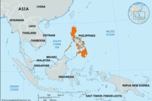
About the Philippines
What it is
-
Southeast Asian archipelago with 7,000+ islands
-
Located in the western Pacific Ocean
Location & Neighbours
-
~800 km east of Vietnam
-
Bordered by:
-
Philippine Sea (east)
-
South China Sea (west)
-
Celebes Sea (south)
-
-
Capital: Manila (Quezon City is most populous city)
Features
-
Coastline: 36,290 km (22,550 miles) → highly exposed to climate impacts
-
Mountains & Volcanoes: About 50 volcanoes (active and dormant)
-
Mount Apo (2,954 m) is the highest peak
-
-
Climate: Tropical; prone to typhoons, floods, earthquakes, and volcanic eruptions
फिलीपींस के पुगाड द्वीप
समाचारों में क्यों
-
समुद्र के बढ़ते स्तर और भूमि धंसाव (प्रति वर्ष 11 सेमी तक) के कारण, फिलीपींस के बुलाकान प्रांत का पुगाड द्वीप तेजी से डूब रहा है
-
फिलीपींस में समुद्र का स्तर वैश्विक औसत से तीन गुना तेजी से बढ़ रहा है
-
वैज्ञानिक चेतावनी दे रहे हैं कि बुलाकान का कुछ हिस्सा पूरी तरह से गायब हो सकता है
फिलीपींस के पुगाड द्वीप के बारे में
क्या है
-
मनीला खाड़ी में एक छोटा द्वीप, लगभग 7 हेक्टेयर आकार का
-
बुलाकान प्रांत की हागोनोय नगरपालिका का एक हिस्सा
-
जनसंख्या: लगभग 2,500 लोग
-
मुख्य आय के स्रोत: मछली पकड़ना और मत्स्य पालन
-
कहाँ स्थित है
-
अंगट–पम्पांगा नदी डेल्टा के मुहाने पर
-
ऐतिहासिक रूप से दलदलों और मैंग्रोव से घिरा हुआ
समस्याएँ और कठिनाइयाँ
-
भूमि धंसाव
-
-
लगभग 11 सेंटीमीटर प्रति वर्ष की दर से धंस रहा है, जो फिलीपींस में सबसे तेज है
-
मुख्य कारण अत्यधिक भूजल दोहन
-
-
समुद्र स्तर वृद्धि
-
-
फिलीपींस में समुद्र स्तर वृद्धि वैश्विक औसत (3.6 मिमी/वर्ष) से 3 गुना
-
आने वाले दशकों में यह 13 मिमी/वर्ष तक पहुँच सकती है
-
-
जलवायु खतरें
-
-
बार-बार बाढ़, टाइफून और तूफानी लहरें
-
जीवन और आजीविका में गंभीर बाधा
-
-
मैंग्रोव का नुकसान
-
-
बड़े पैमाने पर मछली तालाबों में परिवर्तन
-
तूफान और बाढ़ से प्राकृतिक सुरक्षा कम, संवेदनशीलता बढ़ी
-
फिलीपींस के बारे में
क्या है
-
दक्षिण-पूर्व एशियाई द्वीपसमूह जिसमें 7,000+ द्वीप शामिल
-
पश्चिमी प्रशांत महासागर में स्थित
स्थान और पड़ोसी
-
वियतनाम के पूर्व में लगभग 800 किमी
-
सीमाएँ:
-
पूर्व: फिलीपीन सागर
-
पश्चिम: दक्षिण चीन सागर
-
दक्षिण: सेलेब्स सागर
-
-
राजधानी: मनीला (क्वेज़ोन सिटी सबसे अधिक आबादी वाला शहर)
विशेषताएँ
-
तटरेखा: 36,290 किमी (22,550 मील) → जलवायु प्रभावों के लिए अत्यधिक संवेदनशील
-
पर्वत और ज्वालामुखी: लगभग 50 ज्वालामुखी (सक्रिय और सुप्त)
-
माउंट अपो (2,954 मी) सबसे ऊँची चोटी
-
-
जलवायु: उष्णकटिबंधीय; टाइफून, बाढ़, भूकंप और ज्वालामुखी विस्फोट की संभावना अधिक

