

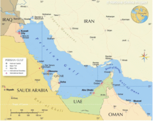
Concerning the Persian Gulf:
-
A section of the Indian Ocean
-
Situated in Western Asia
-
Gulf of Oman extension that joins the Indian Ocean through the Strait of Hormuz (east)
-
Also referred to as the Gulf of Iran or the Arabian Gulf
-
Lies in between:
-
The southwest Arabian Peninsula
-
Northeastern Iran
-
Area and Depth:
-
Area: roughly 251,000 km²
-
Depth: 90 meters at most
-
50 meters on average
Coastline:
-
Iran has the longest coastline (1,536 km), with a total length of 5,117 km
Limitations:
-
North: Iran
-
On the Arabian Peninsula: Qatar, Saudi Arabia, and the United Arab Emirates
-
Kuwait, Bahrain, and Iraq (northwest)
Important Features:
-
The Shatt al-Arab river delta, which was created by the Euphrates and Tigris rivers, marks the western end
Islands:
-
Bahrain: consists of more than fifty islands, with Bahrain Island at its centre
-
Qeshm Island is the Persian Gulf’s largest island, measuring 1,491 km² and roughly 2.5 times the size of Bahrain
-
The Euphrates created the al-Arab river delta
What is a Gulf?
-
A section of the sea with a narrow opening that is nearly completely encircled by land
Creation:
-
An indentation that fills with water is created when a massive rock collapses or when land sinks
-
Gulfs can also be created by natural erosion
पारस की खाड़ी (Persian Gulf) के बारे में:
-
हिंद महासागर का एक हिस्सा
-
पश्चिमी एशिया में स्थित
-
ओमान की खाड़ी का विस्तार जो होरमुज़ जलडमरूमध्य (पूर्व) के माध्यम से हिंद महासागर से जुड़ता है
-
इसे ईरान की खाड़ी या अरब की खाड़ी भी कहा जाता है
-
इसके बीच में स्थित हैं:
-
दक्षिण-पश्चिम में अरब प्रायद्वीप
-
उत्तर-पूर्व में ईरान
-
क्षेत्रफल और गहराई:
-
क्षेत्रफल: लगभग 2,51,000 वर्ग किलोमीटर
-
अधिकतम गहराई: 90 मीटर
-
औसत गहराई: 50 मीटर
तटरेखा:
-
ईरान की तटरेखा सबसे लंबी है (1,536 किलोमीटर), कुल लंबाई: 5,117 किलोमीटर
सीमाएं:
-
उत्तर में: ईरान
-
अरब प्रायद्वीप पर: कतर, सऊदी अरब और संयुक्त अरब अमीरात
-
उत्तर-पश्चिम में: कुवैत, बहरीन और इराक
महत्त्वपूर्ण विशेषताएँ:
-
शट्ट अल-अरब नदी डेल्टा जो यूफ्रेट्स और टिग्रिस नदियों द्वारा बनाया गया है, खाड़ी के पश्चिमी छोर को चिह्नित करता है
द्वीप:
-
बहरीन: इसमें पचास से अधिक द्वीप शामिल हैं, जिनका केंद्र बहरीन द्वीप है
-
क़ेश्म द्वीप पारस की खाड़ी का सबसे बड़ा द्वीप है, जिसका क्षेत्रफल 1,491 वर्ग किलोमीटर है, जो बहरीन से लगभग 2.5 गुना बड़ा है
-
यूफ्रेट्स नदी द्वारा अल-अरब नदी डेल्टा का निर्माण हुआ
खाड़ी क्या होती है?
-
समुद्र का एक भाग जो संकीर्ण मुहाने से खुलता है और लगभग चारों ओर से भूमि से घिरा होता है
निर्माण:
-
जब विशाल चट्टान ध्वस्त हो जाती है या भूमि धँस जाती है, तो एक अवकाश बनता है जो पानी से भर जाता है
-
प्राकृतिक अपरदन (erosion) से भी खाड़ी का निर्माण हो सकता है |

