
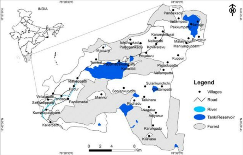
Location:
The Kalvarayan Hills are a prominent hill range located in the Eastern Ghats of Tamil Nadu.
They span across Kallakurichi and parts of Salem districts in southern India.
Watershed Role:
These hills, along with the Pachaimalai, Javadi, and Shevaroy Hills, serve as a natural divide between two major river basins.
They separate the Kaveri River basin (to the south) from the Palar River basin (to the north).
Height and Spread:
The hills rise between 2000 feet to 3000 feet.
The total area covered by the hills is around 1095 square kilometers.
Divisions of the Hills:
The Kalvarayan Hills are divided into:
Chinna Kalvarayan Hills (“Little Kalvarayans”) in the north, averaging 2700 feet in height.
Periya Kalvarayan Hills (“Big Kalvarayans”) in the south, averaging 4000 feet.
Vegetation Types:
Scrub forests: Found at elevations up to 400 metres.
Deciduous forests: Found above 800 metres, typical of tropical dry deciduous ecosystems.
Shola forests: Found on isolated plateaus, indicating montane vegetation pockets.
Water Bodies and Tourism:
Waterfalls: Notable ones include Megam Falls and Periyar Falls, both drawing local tourism.
Dam: The Gomukhi Dam, built across the Gomukhi River, supports local irrigation and water supply.
Tribal Inhabitants:
The dominant tribal community in the region is the Malayali (Malaiyali) Tribe.
They primarily practice shifting agriculture, and their culture is closely linked with the hill ecosystem.
Additional Facts:
The Kalvarayan Hills are part of the Eastern Ghats biodiversity hotspot.
They support rare medicinal plants, endemic flora, and are of ecological importance.
In recent years, efforts have been made to develop eco-tourism in the region.
कलवरायण पहाड़ियाँ:-
स्थान:
कल्वरायन हिल्स भारत के दक्षिणी राज्य तमिलनाडु के पूर्वी घाट (Eastern Ghats) में स्थित एक प्रमुख पहाड़ी श्रृंखला है।
ये पहाड़ियाँ मुख्यतः कल्लकुरिची और आंशिक रूप से सेलम जिले में फैली हुई हैं।
जल विभाजक की भूमिका:
ये पहाड़ियाँ, पचैमलाई, जवदी और शेवरॉय हिल्स के साथ मिलकर, दो प्रमुख नदी घाटियों के बीच प्राकृतिक जल विभाजक का कार्य करती हैं।
ये कावेरी नदी घाटी (दक्षिण में) और पालार नदी घाटी (उत्तर में) को अलग करती हैं।
ऊंचाई और विस्तार:
पहाड़ियों की ऊँचाई लगभग 2000 फीट से 3000 फीट के बीच होती है।
यह क्षेत्र लगभग 1095 वर्ग किलोमीटर में फैला हुआ है।
विभाजन:
कल्वरायन हिल्स को दो भागों में विभाजित किया गया है:
छोटे कल्वरायन (Chinna Kalvarayan): यह उत्तरी भाग है, जिसकी औसत ऊँचाई लगभग 2700 फीट है।
बड़े कल्वरायन (Periya Kalvarayan): यह दक्षिणी भाग है, जिसकी औसत ऊँचाई लगभग 4000 फीट है।
वनस्पति:
झाड़ीदार वन (Scrub Forests): समुद्र तल से 400 मीटर की ऊँचाई तक पाए जाते हैं।
पर्णपाती वन (Deciduous Forests): 800 मीटर से ऊपर की ऊँचाई पर स्थित होते हैं।
शोला वन (Shola Forests): ये एकांत पठारों पर पाए जाते हैं और यह पर्वतीय पारिस्थितिकी तंत्र का भाग हैं।
जल स्रोत और पर्यटन:
जलप्रपात (Waterfalls): प्रमुख जलप्रपातों में मेघम फॉल्स और पेरियार फॉल्स शामिल हैं, जो पर्यटकों को आकर्षित करते हैं।
बांध (Dam): यहाँ का प्रमुख बांध है गोमुखी बांध, जो सिंचाई और जल आपूर्ति में सहायक है।
जनजातियाँ:
यहाँ की प्रमुख जनजातीय आबादी मलयाली (मलैयाली) जनजाति है।
वे पारंपरिक रूप से झूम कृषि (shifting agriculture) करते हैं और इनका जीवन पहाड़ी पर्यावरण से गहराई से जुड़ा है।
अतिरिक्त तथ्य:
कल्वरायन हिल्स, पूर्वी घाट जैव विविधता क्षेत्र (Eastern Ghats Biodiversity Hotspot) का हिस्सा हैं।
यहाँ कई औषधीय पौधे, स्थानिक वनस्पतियाँ और पारिस्थितिक महत्त्व के जीव पाए जाते हैं।
राज्य सरकार द्वारा यहां इको-टूरिज्म (Eco-tourism) को बढ़ावा देने के प्रयास किए जा रहे हैं।

 Mon - Fri: 09:00 - 20:00 Sat & Sun : 10:30 - 18:00

