

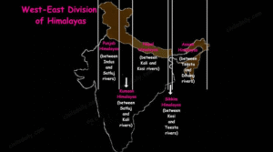
Place and Geography
-
The Himalayas of Bhutan and Nepal form its eastern and western borders.
-
A tiny but crucial section of the Himalayas.
-
Includes deep valleys and lofty mountain peaks like Kanchenjunga (Kanchengiri).
-
Renowned for rivers like Teesta that flow quickly.
-
Has no Shiwalik formations, in contrast to other parts of the Himalayas.
-
Has Duar formations instead, which are utilised for tea gardens.
Tribes and Human Settlement
-
Higher elevations are home to Lepchas.
-
Tribes from Central India, Bengal, and Nepal, mostly in the lower Darjeeling Himalayas.
-
This area is also home to Bhotiyas, who have Tibetan ancestry.
-
Both Doms and Khasas have historically lived there.
-
The Khasas migrated from Kashmir to Assam.
-
-
Kanets are Khasa descendants in Himachal Pradesh.
Tea Plantations
-
Introduced by the British due to favourable conditions:
-
Moderate slopes.
-
Dense soil with high organic content.
-
Evenly distributed rainfall throughout the year.
-
Mild winters.
-
Geology
-
Lies in a zone where Indian and Eurasian plates converge almost perpendicularly to the Himalayan deformation front.
-
High-grade gneissic rocks exposed around Teesta half-window.
-
Lingtse gneiss forms a tectonic zone around Rumtek and Dikchu (Sikkim).
Climate
-
South: subtropical climate.
-
North: tundra climate.
-
Inhabited areas: mostly temperate.
-
Average summer temperature rarely exceeds 28 °C.
-
Average annual temperature: 18 °C.
-
-
Snow line: 6,100–4,900 metres.
-
Northern tundra region snowbound for about 4 months.
-
Night temperature often below 0 °C.
-
-
Heavy monsoon rains cause landslides.
-
Winter and monsoon seasons bring dense fog, making travel risky.
Flora
-
Wide variety due to altitudinal gradation:
-
Tropical: orchids, figs, laurel, bananas, sal trees, bamboo.
-
Alpine vegetation: between 3,500–5,000 metres.
-
Fauna
-
Rich wildlife including:
-
Snow leopards, musk deer, red pandas, Himalayan marmots, serows, gorals, muntjacs, langurs, black bears, clouded leopards, marbled cats, leopard cats, dholes, Tibetan wolves, hog badgers, binturongs, jungle cats.
-
-
Yaks common in alpine zones.
-
Raised for milk, meat, and transport.
-
Cultural and Historical Significance
-
Darjeeling’s Namgyal Institute of Tibetology houses one of the largest collections of Tibetan art and iconography.
Economic and Tourism Significance
-
World-famous Darjeeling Tea Industry.
-
Darjeeling Himalayan Railway, a UNESCO World Heritage site.
-
Duar formations (Himalayan foothill floodplains) aid tea garden development.
-
Spectacular views of Kanchenjunga, the world’s third-highest peak.
दार्जिलिंग और सिक्किम के हिमालयी क्षेत्र:
स्थान और भूगोल
-
भूटान और नेपाल के हिमालय इसके क्रमशः पूर्वी और पश्चिमी सीमा बनाते हैं।
-
हिमालय का एक छोटा लेकिन महत्वपूर्ण हिस्सा।
-
गहरी घाटियाँ और ऊँचे पर्वत शिखर जैसे कंचनजंघा (कंचनगिरि) शामिल हैं।
-
तीव्र गति से बहने वाली नदियों जैसे तीस्ता के लिए प्रसिद्ध।
-
हिमालय के अन्य भागों के विपरीत यहाँ शिवालिक संरचनाएँ नहीं हैं।
-
इसके स्थान पर यहाँ डुआर संरचनाएँ हैं, जिनका उपयोग चाय बागानों के लिए किया जाता है।
जनजातियाँ और मानव बसावट
-
ऊँचाई वाले क्षेत्रों में लेपचा निवास करते हैं।
-
मध्य भारत, बंगाल और नेपाल की जनजातियाँ, मुख्यतः निचले दार्जिलिंग हिमालय में।
-
यहाँ भोटिया भी रहते हैं, जिनकी तिब्बती वंशावली है।
-
डोम और खासा ऐतिहासिक रूप से यहाँ रहते आए हैं।
-
खासा कश्मीर से असम की ओर प्रवास कर गए।
-
-
कानेट हिमाचल प्रदेश में खासा वंशज हैं।
चाय के बागान
-
ब्रिटिशों द्वारा अनुकूल परिस्थितियों के कारण शुरू किए गए:
-
मध्यम ढालें।
-
उच्च कार्बनिक पदार्थ वाली घनी मिट्टी।
-
वर्ष भर समान रूप से वितरित वर्षा।
-
हल्की सर्दियाँ।
-
भूविज्ञान
-
यह उस क्षेत्र में स्थित है जहाँ भारतीय और यूरेशियाई प्लेटें लगभग लंबवत हिमालयी विकृति मोर्चे पर मिलती हैं।
-
तीस्ता हाफ-विंडो के आसपास उच्च श्रेणी की ग्नाइस चट्टानें उजागर होती हैं।
-
लिंग्त्से ग्नाइस, रुमटेक और दिकचु (सिक्किम) के चारों ओर एक टेक्टोनिक क्षेत्र बनाती है।
जलवायु
-
दक्षिण: उपोष्णकटिबंधीय जलवायु।
-
उत्तर: टुंड्रा जलवायु।
-
आबादी वाले क्षेत्र: मुख्यतः समशीतोष्ण।
-
औसत ग्रीष्मकालीन तापमान शायद ही 28 °C से अधिक होता है।
-
औसत वार्षिक तापमान: 18 °C।
-
-
हिमरेखा: 6,100–4,900 मीटर।
-
उत्तरी टुंड्रा क्षेत्र लगभग 4 महीने तक हिमाच्छादित रहता है।
-
रात्रि तापमान अक्सर 0 °C से नीचे रहता है।
-
-
भारी मानसूनी वर्षा से भूस्खलन होता है।
-
शीत और मानसून ऋतु में घना कोहरा छा जाता है, जिससे यात्रा जोखिमपूर्ण हो जाती है।
वनस्पति
-
ऊँचाई के आधार पर विभिन्नता:
-
उष्णकटिबंधीय: ऑर्किड, अंजीर, लॉरेल, केला, साल वृक्ष, बाँस।
-
अल्पाइन वनस्पति: 3,500–5,000 मीटर के बीच।
-
जीव-जंतु
-
समृद्ध वन्यजीवन जिसमें शामिल हैं:
-
हिम तेंदुए, कस्तूरी मृग, लाल पांडा, हिमालयी मर्मोट, सेरो, गोरल, मुंटजैक, लंगूर, काले भालू, धूमिल तेंदुए, संगमरमर बिल्ली, तेंदुआ बिल्ली, ढोल, तिब्बती भेड़िये, हॉग बैजर, बिंटुरॉन्ग, जंगल बिल्ली।
-
-
याक अल्पाइन क्षेत्रों में सामान्य हैं।
-
दूध, मांस और परिवहन के लिए पाले जाते हैं।
-
सांस्कृतिक और ऐतिहासिक महत्व
-
दार्जिलिंग का नामग्याल तिब्बतोलॉजी संस्थान तिब्बती कला और आइकनोग्राफी के सबसे बड़े संग्रहों में से एक का घर है।
आर्थिक और पर्यटन महत्व
-
विश्व प्रसिद्ध दार्जिलिंग चाय उद्योग।
-
दार्जिलिंग हिमालयी रेलवे, एक यूनेस्को विश्व धरोहर स्थल।
-
डुआर संरचनाएँ (हिमालयी तराई के मैदानी बाढ़ क्षेत्र) चाय बागानों के विकास में सहायक।
-
विश्व की तीसरी सबसे ऊँची चोटी कंचनजंघा के मनमोहक दृश्य।

