

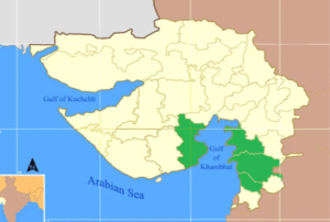
Gulf of Khambhat (also known as the Gulf of Cambay)
Basic Information
-
A triangular Arabian Sea inlet on India’s west coast
-
Situated in the state of Gujarat
-
Opens from the south into the Arabian Sea
-
The Gulf of Cambay is another name for it
Geographical Characteristics
-
Divides Gujarat’s southeast from the Kathiawar Peninsula
-
The gulf’s mouth:
-
Close to Daman and Diu
-
Roughly 190 km wide
-
Narrows to 24 km with significant tidal rapids
-
-
Shallow bay features:
-
Sand dunes and shoals
-
Intertidal mud and sand plains
-
Vast estuarine habitats, particularly in the Sabarmati and Mahi deltas
-
-
Western side:
-
Small inlets are home to a few coral reefs
-
Hydrology
-
Gets water from a number of significant rivers:
-
The Narmada
-
The Tapti
-
Mahi
-
Sabarmati
-
-
In total, Gujarat sends:
-
Five large rivers
-
Five medium rivers
-
Twenty-five small rivers
-
Five desert rivers into this gulf
-
Tidal Characteristics
-
Renowned for having one of India’s largest tidal ranges, reaching up to 12 meters
-
High tidal velocity is due to:
-
The gulf’s shape
-
Orientation with regard to the south-west monsoon winds
-
Historical and Human Significance
-
The city of Khambhat is situated at the gulf’s mouth
-
Historical port cities on the eastern side:
-
Bharuch
-
Surat
-
-
These cities were associated with early European trade with India
-
The area is important for:
-
Riverine ecosystems
-
Fishing
-
Shipping
-
खंभात की खाड़ी :
खंभात की खाड़ी (जिसे कंबे की खाड़ी भी कहा जाता है)
मूल जानकारी
-
भारत के पश्चिमी तट पर अरब सागर की त्रिकोणीय खाड़ी
-
गुजरात राज्य में स्थित
-
दक्षिण से अरब सागर में खुलती है
-
इसे कंबे की खाड़ी के नाम से भी जाना जाता है
भौगोलिक विशेषताएँ
-
गुजरात के दक्षिण-पूर्व को काठियावाड़ प्रायद्वीप से अलग करती है
-
खाड़ी का मुहाना:
-
दमन और दीव के पास स्थित
-
लगभग 190 किमी चौड़ा
-
24 किमी तक संकरा हो जाता है, जिसमें तीव्र ज्वारीय धाराएँ पाई जाती हैं
-
-
उथली खाड़ी की विशेषताएँ:
-
रेत के टीले और छिछले क्षेत्र
-
ज्वार भाटे वाले कीचड़ और रेत के मैदान
-
विशेष रूप से साबरमती और माही डेल्टाओं में विशाल एस्टुअरीन (नदीमुखी) पारिस्थितिकी तंत्र
-
-
पश्चिमी किनारे पर:
-
कुछ छोटे मुहानों में प्रवाल भित्तियाँ पाई जाती हैं
-
जल विज्ञान
-
कई प्रमुख नदियों से जल प्राप्त करती है:
-
नर्मदा
-
तापी
-
माही
-
साबरमती
-
-
कुल मिलाकर, गुजरात से इस खाड़ी में जाती हैं:
-
पाँच बड़ी नदियाँ
-
पाँच मध्यम नदियाँ
-
पच्चीस छोटी नदियाँ
-
पाँच मरुस्थलीय नदियाँ
-
ज्वारीय विशेषताएँ
-
भारत की सबसे बड़ी ज्वारीय सीमा वाली खाड़ियों में से एक, जो 12 मीटर तक पहुँचती है
-
उच्च ज्वारीय वेग के कारण:
-
खाड़ी की आकृति
-
दक्षिण-पश्चिम मानसूनी हवाओं के प्रति इसका अभिविन्यास
-
ऐतिहासिक और मानवीय महत्व
-
खंभात शहर खाड़ी के मुहाने पर स्थित है
-
पूर्वी तट पर ऐतिहासिक बंदरगाह नगर:
-
भरूच
-
सूरत
-
-
ये नगर भारत के साथ प्रारंभिक यूरोपीय व्यापार से जुड़े हुए थे
-
यह क्षेत्र महत्वपूर्ण है:
-
नदी तटीय पारिस्थितिकी तंत्र के लिए
-
मत्स्य पालन के लिए
-
नौवहन के लिए
-

