
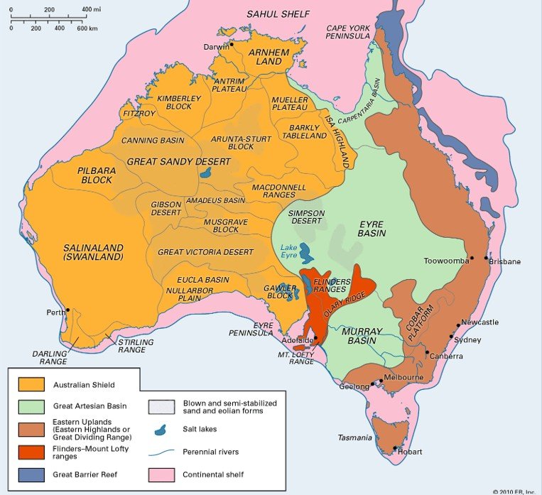
The Eastern Plateau of Australia is also known as the Great Dividing Range.
It runs parallel to the eastern coast of Australia for about 3,500 km.
It extends from Cape York Peninsula in Queensland to Victoria in the south.
The plateau separates the coastal plain from the interior lowlands.
The region features rugged mountains, steep slopes, and deep valleys.
Key ranges include the Blue Mountains, Australian Alps, and Snowy Mountains.
The highest peak of the plateau is Mount Kosciuszko (2,228 m).
It forms a watershed divide between rivers flowing to the east and west.
Important rivers originating here are Murray, Darling, and Fitzroy.
The eastern slopes receive heavy rainfall, supporting dense forests.
The climate varies from tropical in the north to temperate in the south.
It includes national parks, such as Lamington and Kosciuszko National Park.
Rich in biodiversity, the region is home to many endemic species.
The plateau supports agriculture, tourism, and hydroelectric power generation.
The Great Dividing Range affects the climate patterns of eastern Australia.
The eastern escarpment causes orographic rainfall, especially in Queensland and NSW.
The plateau’s western slopes are relatively drier and less densely populated.
Several urban centers like Canberra and Toowoomba lie on or near the plateau edge.
The Snowy Mountains Scheme is a major hydropower project in the southern plateau.
The region plays a key role in Australia’s water, energy, and ecological balance.
पूर्वी पठार (ऑस्ट्रेलिया):-
पूर्वी पठार को ऑस्ट्रेलिया में ग्रेट डिवाइडिंग रेंज भी कहा जाता है।
यह ऑस्ट्रेलिया के पूर्वी तट के समानांतर लगभग 3,500 किमी तक फैला हुआ है।
यह केप यॉर्क प्रायद्वीप (क्वींसलैंड) से लेकर विक्टोरिया तक विस्तृत है।
यह पठार तटीय मैदानों को आंतरिक निम्नभूमियों से अलग करता है।
इस क्षेत्र में बीहड़ पर्वत, खड़ी ढलानें और गहरी घाटियाँ पाई जाती हैं।
प्रमुख पर्वत श्रृंखलाओं में ब्लू माउंटेन्स, ऑस्ट्रेलियन एल्प्स, और स्नोई माउंटेन्स शामिल हैं।
पठार की सबसे ऊँची चोटी है माउंट कोसियस्ज़को (2,228 मीटर)।
यह एक जल विभाजक रेखा बनाता है, जहाँ से नदियाँ पूर्व और पश्चिम की ओर बहती हैं।
यहाँ से निकलने वाली प्रमुख नदियाँ हैं मरे, डार्लिंग, और फिट्ज़रॉय।
इसके पूर्वी ढलानों पर भारी वर्षा होती है, जिससे सघन वन पाए जाते हैं।
यहाँ की जलवायु उत्तर में उष्णकटिबंधीय और दक्षिण में समशीतोष्ण है।
इसमें राष्ट्रीय उद्यान, जैसे कि लामिंग्टन और कोसियस्ज़को नेशनल पार्क शामिल हैं।
यह क्षेत्र जैव विविधता से भरपूर है और यहाँ कई स्थानिक प्रजातियाँ पाई जाती हैं।
पठार में कृषि, पर्यटन, और जलविद्युत उत्पादन के साधन मौजूद हैं।
ग्रेट डिवाइडिंग रेंज ऑस्ट्रेलिया के पूर्वी जलवायु पैटर्न को प्रभावित करता है।
इसकी ढलानों पर ऊरोग्राफिक वर्षा होती है, विशेषकर क्वींसलैंड और न्यू साउथ वेल्स में।
पश्चिमी ढलानें अपेक्षाकृत सूखी होती हैं और कम आबादी वाली होती हैं।
कई शहरी केंद्र, जैसे कैनबरा और टुवूम्बा, इस पठार के किनारे पर स्थित हैं।
स्नोई माउंटेन्स योजना इस पठारी क्षेत्र की एक प्रमुख जलविद्युत परियोजना है।
यह क्षेत्र ऑस्ट्रेलिया के जल संसाधन, ऊर्जा, और पारिस्थितिक संतुलन में महत्वपूर्ण भूमिका निभाता है।

 Mon - Fri: 09:00 - 20:00 Sat & Sun : 10:30 - 18:00

