

Overview of the Cook Islands
In General
-
The Cook Islands are a collection of 15 tiny islands
-
They span 2 million square kilometres in the South Pacific Ocean
-
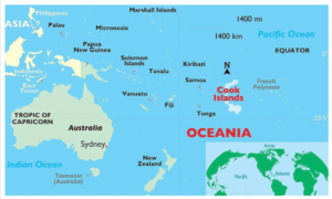
Geographically situated in both the Eastern and Southern hemispheres
-
Located roughly midway between Hawaii and New Zealand, in the middle of the Polynesian Triangle
-
Total land area: 240 square kilometres
Geographical Position
-
To the east: Tonga, Samoa, and Niue
-
Northeast of: New Zealand
-
To the south: Kiribati
-
To the west: French Polynesia
A Historical Remark
-
Named for the 1773 exploration of them by Captain James Cook
-
Tribes with mixed Polynesian ancestry lived there at first
-
It was autonomous
Groups of Islands
Northern Group (6 islands)
-
Manihiki
-
Nassau
-
Penrhyn
-
Pukapuka
-
Rakahanga
-
Suwarrow
-
Sparsely inhabited
-
Low-lying coral atolls
-
White sand beaches and sparse vegetation
Southern Group (9 islands)
-
Rarotonga
-
Aitutaki
-
Atiu
-
Mangaia
-
Manuae
-
Mauke
-
Mitiaro
-
Palmerston
-
Takutea
-
Larger and more densely populated
-
Volcanic origin
-
The northern and southern groups are far apart
Topography
-
Rarotonga Island’s Te Manga (652 m) is the highest point
-
Rarotonga is home to the majority of the population
Capital
-
Rarotonga Island’s capital: Avarua
Governance and Political Status
-
A sovereign nation that has been in free association with New Zealand since August 1965
-
Cook Islanders are citizens of New Zealand
-
Freedom of movement: They have unrestricted access to Australia and New Zealand
Governmental Structure
-
Constitutional monarchy
-
Parliamentary democracy
Money
-
The New Zealand dollar (NZD)
कुक द्वीपसमूह :
कुक द्वीपसमूह का अवलोकन
सामान्य जानकारी
-
कुक द्वीपसमूह 15 छोटे द्वीपों का समूह है
-
ये दक्षिण प्रशांत महासागर में 20 लाख वर्ग किलोमीटर क्षेत्र में फैले हुए हैं
-
भौगोलिक रूप से पूर्वी और दक्षिणी गोलार्धों में स्थित
-
हवाई और न्यूज़ीलैंड के बीच लगभग मध्य में, पॉलिनेशियन त्रिभुज के बीच में स्थित
-
कुल भूमि क्षेत्रफल: 240 वर्ग किलोमीटर
भौगोलिक स्थिति
-
पूर्व में: टोंगा, समोआ, और न्युई
-
उत्तर-पूर्व में: न्यूज़ीलैंड
-
दक्षिण में: किरिबाती
-
पश्चिम में: फ्रेंच पोलिनेशिया
ऐतिहासिक टिप्पणी
-
1773 में कप्तान जेम्स कुक द्वारा किए गए अन्वेषण के नाम पर रखा गया
-
पहले मिश्रित पॉलिनेशियन वंश की जनजातियाँ यहाँ रहती थीं
-
यह स्वायत्त था
द्वीपों के समूह
उत्तरी समूह (6 द्वीप)
-
मानीहीकी
-
नासाउ
-
पेनरिन
-
पुकापुका
-
राकाहांगा
-
सुवारो
-
विरल जनसंख्या
-
नीचले प्रवाल द्वीप (कोरल एटोल)
-
सफेद रेत वाले समुद्र तट और विरल वनस्पति
दक्षिणी समूह (9 द्वीप)
-
रारोटोंगा
-
एइटुटाकी
-
एटियु
-
मंगैया
-
मानुए
-
माउके
-
मिटियारो
-
पामरस्टन
-
टाकुटीआ
-
आकार में बड़े और अधिक आबादी वाले
-
ज्वालामुखीय मूल के
-
उत्तरी और दक्षिणी समूह एक-दूसरे से काफी दूर हैं
स्थलाकृति
-
रारोटोंगा द्वीप का ते मांग (652 मीटर) सबसे ऊँचा बिंदु है
-
रारोटोंगा में अधिकांश जनसंख्या निवास करती है
राजधानी
-
रारोटोंगा द्वीप की राजधानी: अवारुआ
शासन और राजनीतिक स्थिति
-
अगस्त 1965 से न्यूज़ीलैंड के साथ स्वतंत्र सहयोग में एक संप्रभु राष्ट्र
-
कुक द्वीपवासी न्यूज़ीलैंड के नागरिक हैं
-
आवाजाही की स्वतंत्रता: उन्हें ऑस्ट्रेलिया और न्यूज़ीलैंड में बिना रोक-टोक आने-जाने की छूट है
शासन प्रणाली
-
संवैधानिक राजतंत्र
-
संसदीय लोकतंत्र
मुद्रा
-
न्यूज़ीलैंड डॉलर (NZD)

