

Borders Beyond Books: Why Indian Mapping Isn’t Just About Drawing Lines
Ever wondered why the UPSC syllabus says “India and its neighbourhood”? Well, it’s not just about knowing who our neighbours are — it’s about why each inch of our border matters. And that’s where Indian Mapping becomes powerful — not just for Prelims, but for your understanding of geopolitics, internal security, and strategy.
Let’s Start With the Basics:
India doesn’t live in isolation. It shares 15,106 km of land borders with 7 countries — and no, Afghanistan hasn’t disappeared — it’s still there via PoK.
Here’s your border buddy list:
-
Pakistan – full of historical baggage
-
China – the dragon we’re always cautious about
-
Nepal & Bhutan – our Himalayan cousins
-
Bangladesh & Myanmar – eastern gateways
-
Afghanistan – technically via PoK (important in strategic maps)
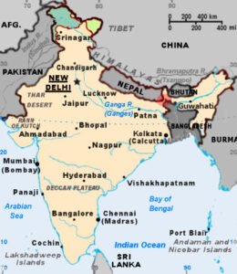
States on the Edge — Literally!
Now imagine you’re drawing a political map. Start noticing these states:
-
Jammu & Kashmir – the gateway to Siachen & LOC dramas
-
Arunachal Pradesh – where China plays the name game
-
Sikkim & Uttarakhand – holding crucial passes like Nathu La & Lipulekh
-
Punjab & Rajasthan – hotbeds of Indo-Pak military history
-
Assam, Tripura, Nagaland, Mizoram – part of the sensitive Northeast that connects through the Chicken’s Neck (Siliguri Corridor)
Each of these states is not just a map entry — they’re strategic sentinels.
Strategic Hotspots You Must Know:
-
Siachen Glacier – the highest battlefield on Earth
-
Kalapani & Lipulekh – India-Nepal map conflict
-
Doklam Plateau – remember the 2017 standoff? Yeah, Bhutan-India-China triangle.
-
Siliguri Corridor – if this gets blocked, the Northeast is cut off from the mainland
These aren’t random spots — they show up in questions, essays, and even interviews. Because geography here becomes geo-strategy.
Map Practice Tips (The UPSC Way):
-
Practice India’s political map with a pencil and a passion
-
Mark borders, rivers, passes, trade routes
-
Know the difference between IB (International Border), LOC (Line of Control), and LAC (Line of Actual Control)
-
Label disputed regions – they often end up in questions
UPSC Connection:
-
Prelims: Map-based MCQs love Northeast and border passes
-
Mains GS1: Geography + Mapping questions
-
GS3: Border management & internal security
-
Interview: “Why does India care so much about the Siliguri Corridor?” — now you’ll have an answer

