

Why in the News
-
Russia recently placed Bastion coastal defence missile launchers along the Barents Sea coast
-
This action initiated “July Storm,” a massive navy-wide drill demonstrating Russia’s military prowess in the Arctic
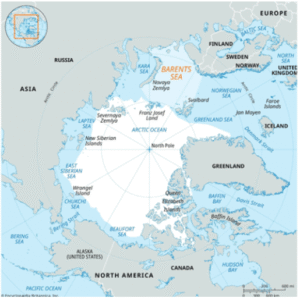
The Barents Sea: What is it?
-
Along the northern coasts of Russia and Norway
-
A marginal sea of the Arctic Ocean
-
Encompasses 1.4 million square kilometres
-
Named for the Dutch navigator Willem Barents, who explored it in the 16th century while looking for a northeast passage to Asia
-
The Murmean Sea is what Vikings and mediaeval Russians called it
Limitations
-
Northwest: Enclosed by the archipelago of Svalbard
-
Northeast: Islands of Franz Josef Land
-
East: The Novaya Zemlya archipelago, which is divided from the Kara Sea by the Kara Strait
-
West: Greenland and Norwegian Seas
-
South: The Peninsula of Kola
Divisions
-
The southern arm of the White Sea divides the Russian mainland from the Kola Peninsula
-
Pechora Sea: Barents Sea’s southeast
Physical Characteristics
-
Maximum Length: 1,050 kilometres
-
Distance: Roughly 1,300 kilometres
-
Depth: 230 meters on average, encompassing a shallow continental shelf
-
Climate: Subarctic, but because of the Gulf Stream, warmer than other sub-Arctic areas
-
Salinity: 34 parts per 1,000 is high
Ecological Importance
-
Abundant in biodiversity:
-
Several colonies of seabirds (guillemots, puffins)
-
Deepwater coral reefs and vast kelp forests
-
-
Marine mammals:
-
Polar bears
-
Bowhead whales
-
Walrus
-
-
A crucial area for regulating the global climate and Arctic marine ecosystems
बारेंट्स सागर
समाचार में क्यों
-
रूस ने हाल ही में बास्टियन तटीय रक्षा मिसाइल लॉन्चरों को बारेंट्स सागर के तट पर तैनात किया
-
इस कार्रवाई ने “जुलाई स्टॉर्म” की शुरुआत की, जो आर्कटिक में रूस की सैन्य शक्ति को दिखाने वाला एक विशाल नौसेना अभ्यास है
बारेंट्स सागर: यह क्या है?
-
रूस और नॉर्वे के उत्तरी तटों के साथ स्थित
-
आर्कटिक महासागर का एक सीमांत सागर
-
1.4 मिलियन वर्ग किलोमीटर के क्षेत्र में फैला है
-
इसका नाम डच नाविक विलेम बारेंट्स के नाम पर पड़ा, जिन्होंने 16वीं शताब्दी में एशिया की ओर उत्तर-पूर्व मार्ग की खोज के दौरान इसका अन्वेषण किया
-
मर्मियन सागर वह नाम था जिससे वाइकिंग्स और मध्यकालीन रूसी इसे पुकारते थे
सीमाएँ
-
उत्तर-पश्चिम: स्वालबार्ड द्वीपसमूह से घिरा है
-
उत्तर-पूर्व: फ्रांज जोसेफ लैंड के द्वीप
-
पूर्व: नोवाया ज़ेमल्या द्वीपसमूह, जो कारा सागर से कारा जलडमरूमध्य द्वारा अलग है
-
पश्चिम: ग्रीनलैंड और नॉर्वेजियन सागर
-
दक्षिण: कोला प्रायद्वीप
विभाजन
-
व्हाइट सागर की दक्षिणी शाखा रूसी मुख्यभूमि को कोला प्रायद्वीप से अलग करती है
-
पेचोरा सागर: बारेंट्स सागर का दक्षिण-पूर्वी भाग
भौतिक विशेषताएँ
-
अधिकतम लंबाई: 1,050 किलोमीटर
-
दूरी: लगभग 1,300 किलोमीटर
-
गहराई: औसतन 230 मीटर, जिसमें एक उथला महाद्वीपीय शेल्फ शामिल है
-
जलवायु: उप-आर्कटिक, लेकिन गल्फ स्ट्रीम के कारण अन्य उप-आर्कटिक क्षेत्रों की तुलना में गर्म
-
लवणता: प्रति 1,000 में 34 भाग, जो कि अधिक है
पारिस्थितिक महत्व
-
जैव विविधता में समृद्ध:
-
कई समुद्री पक्षी उपनिवेश (गिलेमॉट, पफिन्स)
-
गहरे पानी की प्रवाल भित्तियाँ और विशाल केल्प वन
-
-
समुद्री स्तनधारी:
-
ध्रुवीय भालू
-
बोहेड व्हेल
-
वालरस
-
-
वैश्विक जलवायु और आर्कटिक समुद्री पारिस्थितिकी तंत्र को नियंत्रित करने वाला एक महत्वपूर्ण क्षेत्र

