

Why in the News
-
Mud waves buried beneath the Atlantic seabed close to Guinea-Bissau date back 117 million years.
-
Discovery reported in a 2025 study published in Global and Planetary Change.
Mud Waves
-
Sedimentary bedforms on the ocean floor that are large and rhythmic.
-
Created by enduring bottom currents that move and mould sediments.
-
In this instance:
-
Formed during the Cretaceous period.
-
Caused by dense saline flows from the young North Atlantic into southern basins.
-
Important Features
-
Size: Hundreds of meters high and more than one kilometre long.
-
Age: Approximately 117 million years.
-
Location: West of Guinea-Bissau, nearly 1 km below the Atlantic seabed.
-
Composition: Sequences of layered sediments that show historical patterns of ocean currents.
-
Associated Currents: Traversed by deep-water density flows via the Equatorial Atlantic Gateway.
Process of Formation
-
Early Water Spill in the Atlantic
-
-
About 117 million years ago, the North Atlantic was still young and partly separated from the south.
-
Salty water from the north poured southwards through a new opening called the Equatorial Atlantic Gateway.
-
-
Underwater Sediment Avalanches
-
-
Dense saline water collided with older, still southern waters rich in mud and organic matter.
-
Triggered massive underwater mud avalanches rushing across the seabed.
-
-
Shaping the Mud Waves
-
-
Persistent deep-sea currents pushed and piled sediments into wave-like forms.
-
These structures became frozen in place and later buried under the ocean floor.
-
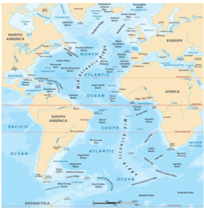
About the Atlantic Ocean
-
Rank: Second-largest ocean after the Pacific, about half its size.
-
Shape: Distinctive S-shaped outline.
-
Key Physical Features:
-
Continental Shelf: Widest in the Northern Atlantic (NE America, NW Europe).
-
Mid-Atlantic Ridge: 14,000 km long, about 4 km high, runs parallel to the ocean’s axis.
-
Seamounts & Islands: Azores, Canary Islands, Bermuda, Cape Verde.
-
Trenches & Troughs: Fewer than in the Pacific; notable ones include Puerto Rico Trench, Romanche Trench.
-
Marginal Seas: Hudson Bay, Baltic Sea, Gulf of Mexico.
-
अटलांटिक समुद्र:
समाचार में क्यों
-
अटलांटिक समुद्र तल के नीचे गिनी-बिसाऊ के पास दबे कीचड़ तरंगें लगभग 11.7 करोड़ वर्ष पुरानी हैं।
-
यह खोज 2025 में ग्लोबल एंड प्लैनेटरी चेंज में प्रकाशित एक अध्ययन में रिपोर्ट की गई।
कीचड़ तरंगों के बारे में
-
समुद्र तल पर पाई जाने वाली बड़ी और लयबद्ध तलछटी संरचनाएं।
-
स्थायी तल धाराओं द्वारा बनाई जाती हैं जो तलछट को हिलाती और आकार देती हैं।
-
इस मामले में:
-
क्रेटेशियस काल के दौरान बनीं।
-
नवयुव अटलांटिक से दक्षिणी बेसिनों में घनी नमकीन धाराओं के कारण बनीं।
-
महत्वपूर्ण विशेषताएं
-
आकार: सैकड़ों मीटर ऊंची और एक किलोमीटर से अधिक लंबी।
-
आयु: लगभग 11.7 करोड़ वर्ष।
-
स्थान: गिनी-बिसाऊ के पश्चिम में, अटलांटिक समुद्र तल के नीचे लगभग 1 किलोमीटर गहराई पर।
-
संरचना: परतदार तलछट का क्रम, जो महासागरीय धाराओं के ऐतिहासिक पैटर्न दिखाता है।
-
संबंधित धाराएं: इक्वेटोरियल अटलांटिक गेटवे से गुजरने वाली गहरे पानी की घनत्व धाराएं।
निर्माण की प्रक्रिया
-
अटलांटिक में शुरुआती पानी का फैलाव
-
-
लगभग 11.7 करोड़ वर्ष पहले, उत्तर अटलांटिक अभी भी युवा था और आंशिक रूप से दक्षिण से अलग था।
-
उत्तर से नमकीन पानी एक नए मार्ग से दक्षिण की ओर बहा जिसे इक्वेटोरियल अटलांटिक गेटवे कहा गया।
-
-
पानी के नीचे तलछट के हिमस्खलन
-
-
घना नमकीन पानी, कीचड़ और जैविक पदार्थ से भरपूर पुराने दक्षिणी पानी से टकराया।
-
इससे समुद्र तल पर बड़े पैमाने पर कीचड़ के हिमस्खलन हुए।
-
-
कीचड़ तरंगों का आकार बनना
-
-
लगातार गहरे समुद्री धाराओं ने तलछट को धकेला और लहर जैसी संरचनाओं में ढेर कर दिया।
-
ये संरचनाएं स्थायी रूप से वहीं जम गईं और बाद में समुद्र तल के नीचे दब गईं।
-
अटलांटिक महासागर के बारे में
-
स्थान: प्रशांत महासागर के बाद दूसरा सबसे बड़ा महासागर, लगभग उसका आधा आकार।
-
आकार: विशिष्ट S-आकार की रूपरेखा।
-
मुख्य भौगोलिक विशेषताएं:
-
महाद्वीपीय शेल्फ: उत्तरी अटलांटिक में सबसे चौड़ा (उत्तर-पूर्व अमेरिका, उत्तर-पश्चिम यूरोप)।
-
मध्य-अटलांटिक रिज: 14,000 किमी लंबा, लगभग 4 किमी ऊंचा, महासागर की धुरी के समानांतर फैला।
-
समुद्री पर्वत और द्वीप: एज़ोरेस, कैनरी द्वीप, बरमूडा, केप वर्डे।
-
खाइयां और गर्त: प्रशांत की तुलना में कम; प्रमुख में प्यूर्टो रिको ट्रेंच, रोमान्चे ट्रेंच।
-
सागरतटीय सागर: हडसन बे, बाल्टिक सागर, मैक्सिको की खाड़ी।
-

