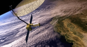
Why in News?
-
India successfully launched the NASA–ISRO Synthetic Aperture Radar (NISAR) satellite aboard GSLV-F16 from Sriharikota on July 31, 2025
-
It marks the first joint Earth observation mission between ISRO and NASA
-
Highlights deep Indo-US space collaboration
-
What is NISAR?
-
Full Form – NASA–ISRO Synthetic Aperture Radar
-
Nature – Joint Earth observation satellite using dual-frequency SAR technology
-
For monitoring land and ice
-
-
Mission Life – 5 years (2025–2030)
-
With 12-day revisit cycles
-
-
Orbit – Sun-synchronous polar orbit (747 km)
-
Ensures consistent lighting and accurate change detection
-
-
Launch Site – Satish Dhawan Space Centre, Sriharikota
-
Aboard GSLV-F16
-
-
First-ever polar orbit mission using GSLV
Objectives of the NISAR Mission
-
Detect minute land and ice surface movements
-
With centimetre-level precision
-
-
Monitor natural disasters
-
Earthquakes
-
Floods
-
Landslides
-
Volcanic activity
-
-
Track environmental changes
-
Forests
-
Glaciers
-
Wetlands
-
Soil moisture
-
-
Support key sectors with actionable data
-
Agriculture
-
Infrastructure
-
Coastal management
-
Climate management
-
Key Features of the NISAR Mission
-
Dual-Frequency SAR
-
First satellite to use both L-band (NASA) and S-band (ISRO) radars
-
-
Wide Swath & High Resolution
-
Scans 242 km swath
-
Provides detailed mapping every 12 days
-
-
All-Weather, 24/7 Imaging
-
Operates day and night
-
Works through clouds and storms
-
-
12-metre Deployable Reflector Antenna
-
Enables advanced SweepSAR technology
-
Used for surface deformation detection
-
Contributions: India vs USA
-
NASA
-
L-band radar
-
Deployable boom
-
Reflector antenna
-
GPS
-
Solid-state recorder
-
Telecom system
-
-
ISRO
-
S-band radar
-
Satellite bus (I-3K)
-
GSLV-F16 launcher
-
Solar arrays
-
Data handling
-
Ground control
-
-
Mission Management
-
Jointly executed via:
-
NASA’s JPL
-
ISRO’s centers: SAC, URSC, VSSC, NRSC
-
-
Significance of the NISAR Mission
-
Scientific Edge
-
Provides global-scale, real-time Earth system monitoring
-
Helps in disaster forecasting
-
-
Strategic Diplomacy
-
Strengthens Indo-US civil space cooperation
-
Promotes “science diplomacy”
-
-
Climate Action & SDGs
-
Supports climate adaptation
-
Enables sustainable agriculture
-
Aids resource governance
-
-
Knowledge Export
-
Open data policy
-
Benefits global researchers and developing nations in Earth sciences
-
Conclusion
-
NISAR is a landmark in Indo-US space partnership
-
Integrates advanced technology with societal benefits
-
Shifts India from utility-driven to knowledge-led space applications
-
Reinforces India’s leadership in Earth observation, sustainability, and global scientific cooperation


