

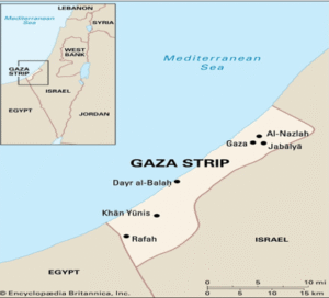
Location of the Gaza Strip
-
Mediterranean coast in the east
-
Israel’s north and east borders and Egypt’s southwest border
-
Location: 31°15′N, 34°19′E
-
360 km² in size
-
40 km coastline
-
Urban and Administrative Profile
-
Gaza City, the capital
-
Home to about 500,000 people
-
-
Additional important hubs
-
Beit Hanoun
-
Jabalia
-
Rafah
-
Khan Yunis
-
-
Districts
-
Rafah
-
Khan Yunis
-
Deir al-Balah
-
Gaza
-
North Gaza
-
People and Society
-
More than two million people live there (very high density)
-
Hamas has been in power since 2007
-
Climate: semi-arid, hot-summer Mediterranean
Challenges and the Economy
-
Economic foundation
-
Agriculture
-
Aid
-
Services
-
Small-scale industry
-
-
Limited exports
-
Fruits
-
Vegetables
-
Olives
-
गाज़ा पट्टी :
गाज़ा पट्टी का स्थान
-
पूर्व में भूमध्यसागर का तट
-
उत्तर और पूर्व में इज़राइल की सीमा तथा दक्षिण-पश्चिम में मिस्र की सीमा
-
स्थान: 31°15′N, 34°19′E
-
360 किमी² क्षेत्रफल
-
40 किमी समुद्र तट
-
शहरी और प्रशासनिक प्रोफ़ाइल
-
गाज़ा सिटी, राजधानी
-
लगभग 5,00,000 लोगों का निवास
-
-
अन्य प्रमुख केंद्र
-
बेत हानून
-
जबालिया
-
रफ़ा
-
खान यूनिस
-
-
ज़िले
-
रफ़ा
-
खान यूनिस
-
देइर अल-बलाह
-
गाज़ा
-
उत्तर गाज़ा
-
लोग और समाज
-
यहाँ 20 लाख से अधिक लोग रहते हैं (बहुत अधिक घनत्व)
-
2007 से हमास सत्ता में है
-
जलवायु: अर्ध-शुष्क, गर्मी वाली भूमध्यसागरीय
चुनौतियाँ और अर्थव्यवस्था
-
आर्थिक आधार
-
कृषि
-
सहायता
-
सेवाएँ
-
लघु उद्योग
-
-
सीमित निर्यात
-
फल
-
सब्ज़ियाँ
-
जैतून
-

