

Why in the News
-
More than 1,000 people killed in a huge landslip in Sudan’s Darfur region
-
An entire mountain village in the Marra Mountains levelled by the catastrophe
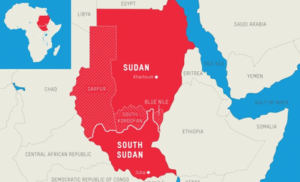
The Sudan
What it is
-
Nation in Africa’s northeast
-
Historically called bilād al-sūdān by Arab geographers of the Middle Ages → “land of the blacks”
-
Became independent in 1956
-
Presently governed by President Gen. Abdel Fattah al-Burhan’s transitional administration
Where it lies
-
Situated where the Arab and African worlds converge
-
Influenced by African and Mediterranean cultures
-
Prior to South Sudan’s 2011 secession, it was the biggest nation in Africa
-
Capital: Khartoum, located at the confluence of the White Nile and Blue Nile
Adjacent Countries
-
Red Sea
-
Egypt
-
Eritrea
-
Ethiopia
-
South Sudan
-
Central African Republic
-
Chad
-
Libya
Key Physical Features
Mountains
-
Marra Mountains in Darfur → volcanic highlands, up to 3,000 m
-
Nuba Mountains → inselbergs
Rivers
-
Dominated by the Nile system
-
White Nile
-
Blue Nile (join at Khartoum)
-
Landforms
-
Vast deserts in the north
-
Sand dunes in the Qawz region
-
Red Sea Hills in the northeast
-
Clay plains in the south-central region
Soils
-
Fertile alluvial clays in the Gezira plain
-
Barren sandy and rocky deserts elsewhere
सूडान भूस्खलन त्रासदी:
क्यों खबर में
-
सूडान के दारफुर क्षेत्र में भीषण भूस्खलन में 1,000 से अधिक लोगों की मौत
-
मर्रा पर्वतों में स्थित पूरा पहाड़ी गाँव तबाह हो गया
सूडान के बारे में
यह क्या है
-
अफ्रीका के उत्तर-पूर्व का राष्ट्र
-
मध्ययुगीन अरब भूगोलविदों द्वारा ऐतिहासिक रूप से बिलाद अल-सूदान कहा गया → “काले लोगों की भूमि”
-
1956 में स्वतंत्र हुआ
-
वर्तमान में राष्ट्रपति जनरल अब्देल फतह अल-बुरहान के नेतृत्व वाली संक्रमणकालीन सरकार द्वारा शासित
कहाँ स्थित है
-
अरब और अफ्रीकी दुनिया के संगम पर स्थित
-
अफ्रीकी और भूमध्यसागरीय संस्कृतियों से प्रभावित
-
2011 में दक्षिण सूडान के अलग होने से पहले यह अफ्रीका का सबसे बड़ा राष्ट्र था
-
राजधानी: खार्तूम, जहाँ श्वेत नील और नीली नील नदियाँ मिलती हैं
पड़ोसी देश
-
लाल सागर
-
मिस्र
-
इरिट्रिया
-
इथियोपिया
-
दक्षिण सूडान
-
मध्य अफ्रीकी गणराज्य
-
चाड
-
लीबिया
प्रमुख भौतिक विशेषताएँ
पर्वत
-
दारफुर में मर्रा पर्वत → ज्वालामुखीय उच्चभूमि, लगभग 3,000 मीटर ऊँचे
-
नूबा पर्वत → आइसलैंड पहाड़ियाँ (इंसेलबर्ग्स)
नदियाँ
-
नील नदी तंत्र का प्रभुत्व
-
श्वेत नील
-
नीली नील (खार्तूम में मिलती हैं)
-
स्थलाकृति
-
उत्तर में विशाल रेगिस्तान
-
काव्ज़ क्षेत्र में रेत के टीलों का विस्तार
-
उत्तर-पूर्व में लाल सागर की पहाड़ियाँ
-
दक्षिण-मध्य क्षेत्र में मिट्टी के मैदानी क्षेत्र
मिट्टी
-
गेज़ीरा मैदान में उपजाऊ जलोढ़ मिट्टी
-
अन्यत्र बंजर रेतीले और चट्टानी रेगिस्तान

