

Why in the News
-
With the operationalisation of National Waterway-57 (River Kopili):
-
Assam’s river-based trade has been revived
-
Sustainable logistics has been promoted
-
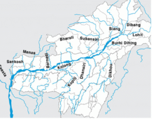
The Kopili River
-
General Information
-
-
A significant major tributary on the left bank of the Brahmaputra
-
Traverses Northeast India’s Meghalaya and Assam
-
The Brahmaputra’s largest south bank tributary in Assam
-
-
Origin
-
-
Rises at a height of 1525 meters
-
Located in the Borail Range’s Saipong Reserve Forest in the North Cachar Hills District
-
-
Length
-
-
256 km in total
-
78 km forms the shared border between Assam and Meghalaya
-
178 km lies in Assam
-
-
Geographic Coverage
-
-
Passes through the districts of:
-
Nagaon
-
Morigaon
-
Karbi Anglong
-
North Cachar Hills
-
-
-
Agriculture in the Neighbourhood
-
-
Principal crops produced include:
-
Winter rice
-
Summer rice
-
Autumn rice
-
Mustard
-
Rape seed
-
Wheat
-
-
Especially around Kamrup district and nearby areas
-
कोपिली नदी :
समाचारों में क्यों
-
नेशनल वॉटरवे-57 (कोपिली नदी) के चालू होने के साथ:
-
असम का नदी-आधारित व्यापार पुनर्जीवित हुआ
-
सतत लॉजिस्टिक्स को बढ़ावा मिला
-
कोपिली नदी के बारे में
-
सामान्य जानकारी
-
-
ब्रह्मपुत्र के बाएं किनारे की एक प्रमुख सहायक नदी
-
उत्तर–पूर्व भारत के मेघालय और असम से होकर बहती है
-
असम में ब्रह्मपुत्र की सबसे बड़ी दक्षिणी तट की सहायक नदी
-
-
उत्पत्ति
-
-
1525 मीटर की ऊंचाई से निकलती है
-
बोरैल रेंज के सैपोंग रिज़र्व फ़ॉरेस्ट में, उत्तर कछार हिल्स ज़िले में स्थित
-
-
लंबाई
-
-
कुल 256 किमी
-
असम और मेघालय की साझा सीमा का 78 किमी हिस्सा
-
असम में 178 किमी का विस्तार
-
-
भौगोलिक विस्तार
-
-
जिन ज़िलों से होकर गुजरती है:
-
नागांव
-
मोरीगांव
-
कार्बी आंगलोंग
-
उत्तर कछार हिल्स
-
-
-
आसपास की कृषि
-
-
मुख्य फसलें जो उगाई जाती हैं:
-
शीतकालीन धान
-
ग्रीष्मकालीन धान
-
शरदकालीन धान
-
सरसों
-
रेपसीड
-
गेहूं
-
-
खासकर कामरूप ज़िले और आस-पास के क्षेत्रों में |
-

