

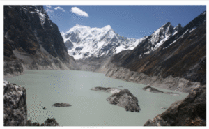
About Glacial Lakes
-
Glacial lakes are bodies of water formed by the melting of glacial ice.
-
They are usually found in basins or depressions that the glaciers have carved out as they move.
-
Based on how they form, glacial lakes can be divided into four categories: erosion, ice-dammed, moraine-dammed, and others.
GLOFs (Glacial Lake Outburst Floods)
-
When a glacial ice dam or moraine fails, meltwater is released.
-
GLOFs have three primary characteristics:
-
Entail abrupt (and occasionally periodic) water releases.
-
Events usually happen quickly and last for several hours or days.
-
Lead to significant river discharges downstream.
-
GLOF Examples
-
2023: The Teesta III Dam in Chungthang, Sikkim, was destroyed by GLOF at South Lhonak.
-
2013: GLOF in the glacial lake of Chorabari and floods in Uttarakhand’s Mandakini River.
Principal Reasons for the Glacial Surging of GLOFs
-
Rapid glacier advance is the result of abrupt ice movement over a brief period of time. For instance, Alaska’s Gilkey Glacier.
-
Moraine dam instability: Structural weakness can cause loose, unconsolidated moraines, which are naturally unstable, to collapse. For instance, the South Lhonak GLOFs in Sikkim.
-
Failure of an ice dam: Their structure is weakened by internal melting, water pressure, and heat stress.
-
Seismic activity: In mountainous areas, tectonic movements can cause abrupt structural changes.
-
Human Activity: Uncontrolled urbanisation, illogical mining, deforestation, hydropower projects, greenhouse gas emissions, and other activities can change the slope’s stability and drainage patterns.
Initiatives Taken in India for the Management of GLOFs
-
Guidelines for the Management of Glacial Lake Outbursts by the National Disaster Management Authority Floods (GLOFs).
-
High-risk glacial lakes in six Himalayan regions have been identified by NDMA, which intends to carry out focused expeditions to evaluate the risks and create all-encompassing mitigation plans.
-
CWC reviews the design flood of all dams that are vulnerable to GLOFs, both those that are being built and those that are already in place.
-
All planned new dams with glacial lakes in their catchments are required to conduct GLOF studies.
-
The Union Home Minister for the States of Himachal Pradesh, Uttarakhand, Sikkim, and Arunachal Pradesh chaired the High-Level Committee that approved the GLOF risk mitigation project.
-
The National Institute of Hydrology, Roorkee, prepared the National Mission on Himalayan Studies’ (NMHS) report on the glacial lakes in the Sikkim Himalayas.
Global Efforts to Monitor Glacial Lakes
-
The International Centre for Integrated Mountain Development’s (ICIMOD) HKH cryosphere initiative.
-
Worldwide Climate Observing System: Promotes government spending on remote sensing and early warning systems to monitor the stability and growth of glacial lakes.
-
The goal of the UNESCO Climate Change and Mountain Ecosystem Program is to reduce human interference in vulnerable areas by promoting conservation and sustainable tourism.
-
The Sendai Framework for Disaster Risk Reduction promotes global collaboration in the management of cross-border GLOF hazards.
Challenges in Managing GLOFs
-
Regular surveys are challenging due to the challenging and extremely inaccessible Himalayan terrain.
-
Absence of early warning systems (EWS), which necessitate extensive infrastructure and careful planning.
-
The Himalayan region’s vulnerability: The Himalayan region is vulnerable to earthquakes and landslides because it is located in Seismic Zones IV and V.
-
Climate change: As temperatures rise, glaciers are getting smaller.
-
According to the International Centre for Integrated Mountain Development (ICIMOD), under a high emission scenario, 70–80% of the Hindu Kush Himalaya’s (HKH) present glacier volume will vanish by 2100.
NDMA Guidelines for the Future
-
Thorough comprehension of GLOF dynamics: Examine the causes, triggers, and mechanisms of GLOFs, paying particular attention to the most recent scientific findings and case studies from the Himalayas and other mountain ranges, including the Alps, Tian Shan Range, and the Andes.
-
Boost Technical Know-How and Develop Capability: Gain more knowledge to improve technical proficiency at the state and federal levels.
-
Encourage cooperation and the creation of strategies: Encourage cooperation between stakeholders, legislators, and experts to create and carry out all-encompassing plans for tracking and reducing GLOF risks.
-
Examining Strategies for Mitigation: Analyse both structural and non-structural mitigation strategies, such as syphoning, controlled breaching, and the building of community-based strategies and outlet control systems.
-
Enhancing Early Warning and Monitoring Systems: Talk about how remote sensing technologies, Geographic Information Systems (GIS), and satellite-based monitoring are combined to predict GLOFs.
-
Examine the creation and application of early warning systems adapted to the particular difficulties faced by the Himalayan region.
ग्लेशियल झीलें :
ग्लेशियल झीलों के बारे में
-
ग्लेशियल झीलें बर्फ के पिघलने से बनी जल निकाय होती हैं।
-
ये आमतौर पर उन घाटियों या गड्ढों में पाई जाती हैं जिन्हें ग्लेशियरों ने अपनी गति से काटा होता है।
-
बनने के आधार पर, ग्लेशियल झीलों को चार श्रेणियों में बांटा जा सकता है: अपरदन, हिम-बांधित, मोरेन-बांधित और अन्य।
GLOFs (ग्लेशियल झील विस्फोट बाढ़)
-
जब कोई ग्लेशियल बर्फ-बांध या मोरेन टूटता है, तो पिघला हुआ पानी बाहर निकलता है।
-
GLOFs की तीन मुख्य विशेषताएँ होती हैं:
-
अचानक (और कभी-कभी आवधिक) जल विमोचन।
-
घटनाएँ आमतौर पर तेजी से घटित होती हैं और कई घंटे या दिनों तक चलती हैं।
-
नीचे की ओर नदियों में भारी जल प्रवाह उत्पन्न करती हैं।
-
GLOF के उदाहरण
-
2023: सिक्किम के दक्षिण लोनाक में GLOF ने चुंगथांग में तीस्ता III बांध को नष्ट कर दिया।
-
2013: चोराबारी झील में GLOF और उत्तराखंड की मंदाकिनी नदी में बाढ़।
GLOFs के हिमस्खलन के मुख्य कारण
-
तीव्र हिम गति: अचानक बर्फ के तेज़ गति से बहाव से तीव्र हिमस्खलन होता है। उदाहरण: अलास्का का गिलकी ग्लेशियर।
-
मोरेन बांध की अस्थिरता: ढीले और असंहित मोरेन की संरचनात्मक कमजोरी के कारण उनका ढह जाना। उदाहरण: सिक्किम में दक्षिण लोनाक GLOFs।
-
बर्फ के बांध की विफलता: आंतरिक पिघलन, जल दबाव और तापीय तनाव से संरचना कमजोर होती है।
-
भूकंपीय गतिविधि: पर्वतीय क्षेत्रों में टेक्टोनिक हलचल से संरचनात्मक बदलाव हो सकते हैं।
-
मानवीय गतिविधि: अनियंत्रित शहरीकरण, अव्यवस्थित खनन, वनों की कटाई, जलविद्युत परियोजनाएं, ग्रीनहाउस गैस उत्सर्जन आदि ढलानों की स्थिरता और जल निकासी में परिवर्तन ला सकते हैं।
भारत में GLOFs प्रबंधन हेतु की गई पहलें
-
राष्ट्रीय आपदा प्रबंधन प्राधिकरण (NDMA) द्वारा ग्लेशियल झील विस्फोट बाढ़ (GLOFs) के प्रबंधन हेतु दिशानिर्देश।
-
NDMA ने छह हिमालयी क्षेत्रों में उच्च-जोखिम वाली ग्लेशियल झीलों की पहचान की है और जोखिमों के मूल्यांकन व शमन योजनाओं के लिए विशेष अभियानों की योजना बनाई है।
-
CWC उन सभी बांधों की डिज़ाइन फ्लड की समीक्षा करता है जो GLOFs के प्रति संवेदनशील हैं, चाहे वे निर्माणाधीन हों या मौजूदा।
-
सभी नियोजित नए बांधों को जिनकी जलग्रहण क्षेत्र में ग्लेशियल झीलें हैं, उन्हें GLOF अध्ययन कराना अनिवार्य है।
-
हिमाचल प्रदेश, उत्तराखंड, सिक्किम और अरुणाचल प्रदेश के लिए केंद्रीय गृह मंत्री की अध्यक्षता में उच्चस्तरीय समिति ने GLOF जोखिम न्यूनीकरण परियोजना को मंजूरी दी है।
-
राष्ट्रीय जल विज्ञान संस्थान, रुड़की ने सिक्किम हिमालय में ग्लेशियल झीलों पर राष्ट्रीय हिमालय अध्ययन मिशन (NMHS) की रिपोर्ट तैयार की।
ग्लेशियल झीलों की निगरानी हेतु वैश्विक प्रयास
-
अंतरराष्ट्रीय पर्वतीय विकास एकीकृत केंद्र (ICIMOD) की HKH क्रायोस्फीयर पहल।
-
विश्वव्यापी जलवायु प्रेक्षण प्रणाली: दूरसंवेदी और प्रारंभिक चेतावनी प्रणालियों में सरकारों के निवेश को बढ़ावा देती है ताकि ग्लेशियल झीलों की स्थिरता और विस्तार की निगरानी की जा सके।
-
यूनेस्को जलवायु परिवर्तन और पर्वतीय पारिस्थितिकी कार्यक्रम का लक्ष्य संवेदनशील क्षेत्रों में मानव हस्तक्षेप को कम करना है, जिसमें संरक्षण और सतत पर्यटन को बढ़ावा दिया जाता है।
-
सेंदाई ढांचा आपदा जोखिम न्यूनीकरण के लिए वैश्विक सहयोग को बढ़ावा देता है, खासकर सीमापार GLOF खतरों के प्रबंधन में।
GLOFs के प्रबंधन में चुनौतियाँ
-
नियमित सर्वेक्षण चुनौतीपूर्ण हैं क्योंकि हिमालयी क्षेत्र बेहद दुर्गम और कठिन हैं।
-
प्रारंभिक चेतावनी प्रणाली (EWS) का अभाव, जिसके लिए भारी बुनियादी ढांचे और सावधानीपूर्वक योजना की आवश्यकता होती है।
-
हिमालयी क्षेत्र की संवेदनशीलता: यह क्षेत्र भूकंपीय जोन IV और V में स्थित होने के कारण भूकंप और भूस्खलन की दृष्टि से संवेदनशील है।
-
जलवायु परिवर्तन: जैसे-जैसे तापमान बढ़ रहा है, ग्लेशियर सिकुड़ते जा रहे हैं।
-
ICIMOD के अनुसार, उच्च उत्सर्जन परिदृश्य के तहत, हिंदूकुश हिमालय (HKH) के वर्तमान ग्लेशियरों का 70–80% हिस्सा 2100 तक समाप्त हो सकता है।
भविष्य के लिए NDMA के दिशानिर्देश
-
GLOF गतिशीलता की विस्तृत समझ: GLOFs के कारणों, ट्रिगर्स और तंत्रों का अध्ययन करें, विशेष रूप से हिमालय और अन्य पर्वतीय श्रृंखलाओं (जैसे आल्प्स, तियान शान रेंज, एंडीज) के नवीनतम वैज्ञानिक निष्कर्षों और केस स्टडीज़ पर ध्यान दें।
-
तकनीकी जानकारी बढ़ाना और क्षमता निर्माण: राज्य और केंद्र स्तर पर तकनीकी दक्षता बढ़ाने के लिए ज्ञान प्राप्त करें।
-
सहयोग को प्रोत्साहन और रणनीतियों का निर्माण: हितधारकों, नीति निर्माताओं और विशेषज्ञों के बीच सहयोग को बढ़ावा दें ताकि GLOF जोखिमों की निगरानी और न्यूनीकरण के लिए समग्र योजनाएं बनाई और लागू की जा सकें।
-
शमन रणनीतियों का परीक्षण: संरचनात्मक और गैर-संरचनात्मक शमन रणनीतियों जैसे सायफनिंग, नियंत्रित ब्रेचिंग, सामुदायिक रणनीतियों और जल निकासी नियंत्रण प्रणालियों का विश्लेषण करें।
-
प्रारंभिक चेतावनी और निगरानी प्रणाली को सुदृढ़ करना: रिमोट सेंसिंग तकनीकों, जियोग्राफिक इन्फॉर्मेशन सिस्टम (GIS), और उपग्रह आधारित निगरानी को GLOFs की भविष्यवाणी हेतु जोड़ने की चर्चा करें।
-
हिमालयी क्षेत्र की विशिष्ट चुनौतियों के अनुसार अनुकूल प्रारंभिक चेतावनी प्रणाली के निर्माण और उपयोग की समीक्षा करें।

