

What is a Gulf?
A gulf is a large water body that forms part of the ocean or sea and extends into the land. It is almost completely surrounded by land on three sides, with only a narrow opening that connects it to the main water body like a sea or ocean.
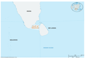
Overview of the Gulf of Mannar
Location:
-
Lies between:
-
India’s southeast coast
-
Sri Lanka’s northwest coast
-
-
A portion of the Indian Ocean’s Laccadive Sea
Extent:
-
About 100 miles long
-
About 125 miles wide
Limitations:
-
Northeast: Island of Rameswaram
-
Adam’s Bridge:
-
Also known as Rama’s Bridge
-
Naturally occurring shoal chain that links Sri Lanka and India
-
-
Sri Lanka’s Mannar Island
Rivers Emptying into the Gulf:
-
River Tambraparni (India)
-
Sri Lanka’s Aruvi River
Crucial Port:
-
Tuticorin (Thoothukudi) on the Indian coast
Unique Qualities:
-
Renowned for:
-
Sacred chank (a mollusc used in rituals)
-
Pearl banks
-
Marine National Park & Biosphere Reserve in the Gulf of Mannar
Special Status:
-
South and Southeast Asia’s first Marine Biosphere Reserve
Where:
-
Lies along the Tamil Nadu coast
-
Between the districts of:
-
Ramanathapuram
-
Tuticorin
-
Islands:
-
Consists of 21 islands
-
Two of which are submerged
-
Ecological Significance:
-
One of the Indian mainland’s most abundant coastal biodiversity areas
-
Home to more than 3600 species of:
-
Plants and animals
-
Coral reefs
-
Seagrass beds
-
Mangroves
-
Dugongs
-
Dolphins
-
Other Important Coral Reef Regions in India:
-
Gujarat’s Gulf of Kutch
-
Islands of Lakshadweep
-
Islands of the Andaman and Nicobar
Status of Conservation:
-
Designated as a Biosphere Reserve by:
-
UNESCO’s Man and Biosphere Programme (MAB)
-
गोल्फ ऑफ मन्नार :
गल्फ क्या है?
एक गल्फ एक बड़ा जल निकाय होता है जो महासागर या सागर का हिस्सा होता है और जो भूमि के भीतर तक फैला होता है। यह लगभग तीन तरफ से भूमि से घिरा होता है, और केवल एक संकीर्ण मार्ग से मुख्य जल निकाय जैसे सागर या महासागर से जुड़ा होता है।
गोल्फ ऑफ मन्नार का अवलोकन
स्थान:
-
स्थित है:
-
भारत के दक्षिण-पूर्वी तट और
-
श्रीलंका के उत्तर-पश्चिमी तट के बीच
-
-
हिंद महासागर के लक्षद्वीप सागर का एक हिस्सा
विस्तार:
-
लगभग 100 मील लंबा
-
लगभग 125 मील चौड़ा
सीमाएँ:
-
उत्तर-पूर्व: रामेश्वरम द्वीप
-
एडम्स ब्रिज:
-
जिसे राम सेतु भी कहा जाता है
-
यह एक प्राकृतिक रूप से बना हुआ रेतीला श्रृंखला है जो श्रीलंका और भारत को जोड़ता है
-
-
श्रीलंका का मन्नार द्वीप
गोल्फ में गिरने वाली नदियाँ:
-
भारत की ताम्रपर्णी नदी
-
श्रीलंका की अरुवी नदी
महत्त्वपूर्ण बंदरगाह:
-
भारतीय तट पर स्थित तूतीकोरिन (थूथुकुडी)
विशिष्टताएँ:
-
प्रसिद्ध:
-
पवित्र शंख (एक धार्मिक क्रियाओं में प्रयुक्त मोलस्क)
-
मोती की खाड़ियों के लिए
-
गोल्फ ऑफ मन्नार में समुद्री राष्ट्रीय उद्यान और बायोस्फीयर रिजर्व
विशेष दर्जा:
-
दक्षिण और दक्षिण-पूर्व एशिया का पहला समुद्री बायोस्फीयर रिजर्व
स्थान:
-
तमिलनाडु के तट के साथ स्थित
-
निम्न जिलों के बीच:
-
रामनाथपुरम
-
तूतीकोरिन
-
द्वीप:
-
इसमें कुल 21 द्वीप शामिल हैं
-
जिनमें से दो जलमग्न हैं
-
पारिस्थितिक महत्त्व:
-
भारतीय मुख्य भूमि के सबसे समृद्ध तटीय जैव विविधता वाले क्षेत्रों में से एक
-
3600 से अधिक प्रजातियाँ शामिल हैं:
-
पौधे और जानवर
-
कोरल रीफ (प्रवाल भित्तियाँ)
-
समुद्री घास के क्षेत्र
-
मैन्ग्रोव
-
डुगोंग (समुद्री गाय)
-
डॉल्फ़िन
-
भारत के अन्य प्रमुख कोरल रीफ क्षेत्र:
-
गुजरात का कच्छ का खाड़ी
-
लक्षद्वीप के द्वीप
-
अंडमान और निकोबार द्वीप समूह
संरक्षण की स्थिति:
-
यूनेस्को के:
-
“मैन एंड बायोस्फीयर” प्रोग्राम (MAB) द्वारा बायोस्फीयर रिजर्व घोषित किया गया है |
-

