

Why in the News
-
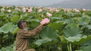
In Wular Lake, Jammu & Kashmir, a carpet of pink and green lotus beds has reappeared after almost 25 years
-
Its reappearance signifies a significant ecological recovery
-
Last observed prior to the devastating floods of 1992
-
Wular Lake
-
Location
-
-
Jammu & Kashmir’s Bandipore district
-
At the base of Haramuk Mountain, 1,580 meters above sea level
-
The Jhelum River is the source
-
The area is roughly 200 square kilometres, 24 kilometres long, and 10 kilometres wide
-
-
Origin
-
-
Tectonic action caused its formation
-
Believed to be a piece of the old Satisar Lake
-
Includes the “Zaina Lank,” a central island built by King Zainul-Abidin
-
-
Recognition
-
-
Designated as a Ramsar Wetland Site (Internationally Important Wetland) in 1990
-
Ecological Importance
-
Provides essential habitat for:
-
-
Breeding
-
Staging
-
Wintering
-
Acts as a vital habitat for birds that breed
-
-
Bird species found near the lake:
-
-
Black-eared kites
-
The Eurasian sparrow hawk
-
Eagle with short toes
-
The golden Himalayan eagle
-
Monal Himalaya
-
-
Accounts for 60% of Jammu & Kashmir’s total fish production
-
Sustains livelihoods through activities related to wetlands and fisheries
About Jhelum River
-
Source
-
-
Starts at Verinag Spring situated in Jammu & Kashmir’s Anantnag district
-
-
Course
-
-
Flows into Wular Lake after passing through Srinagar
-
Enters Pakistan and keeps moving west
-
-
Confluence
-
-
Joins the Chenab River in Pakistan, close to Trimmu
-
-
Principal Tributaries
-
-
The Kishenganga River, also known as Neelum in Pakistan
-
River Kunhar
-
वुलर झील:
क्यों चर्चा में है
-
वुलर झील, जम्मू और कश्मीर में, लगभग 25 वर्षों के बाद गुलाबी और हरे कमल की चादर फिर से दिखाई दी है
-
इसका पुन: प्रकट होना एक महत्वपूर्ण पारिस्थितिकीय सुधार को दर्शाता है
-
इसे आखिरी बार 1992 की विनाशकारी बाढ़ से पहले देखा गया था
-
वुलर झील के बारे में
-
स्थान
-
-
जम्मू और कश्मीर के बांदीपोरा ज़िले में
-
हरमुक पर्वत की तलहटी में, समुद्र तल से 1,580 मीटर की ऊंचाई पर
-
झेलम नदी इसका स्रोत है
-
क्षेत्रफल लगभग 200 वर्ग किलोमीटर, लंबाई 24 किलोमीटर और चौड़ाई 10 किलोमीटर
-
-
उत्पत्ति
-
-
टेक्टोनिक क्रिया के कारण इसका निर्माण हुआ
-
माना जाता है कि यह प्राचीन सतीसर झील का एक हिस्सा है
-
इसमें “ज़ैना लंक” शामिल है, जो राजा ज़ैनुल-अबिदीन द्वारा बनाया गया एक केंद्रीय द्वीप है
-
-
मान्यता
-
-
1990 में इसे रामसर वेटलैंड साइट (अंतरराष्ट्रीय रूप से महत्वपूर्ण आर्द्रभूमि) के रूप में नामित किया गया था
-
पारिस्थितिकीय महत्त्व
-
आवश्यक आवास प्रदान करती है:
-
-
प्रजनन
-
प्रवास
-
शीतकालीन प्रवास
-
यह पक्षियों के प्रजनन के लिए एक महत्वपूर्ण आवास है
-
-
झील के पास पाए जाने वाले पक्षी प्रजातियाँ:
-
-
काले-कान वाली चील
-
यूरेशियन स्पैरो हॉक
-
छोटे पंजों वाला ईगल
-
सुनहरी हिमालयन ईगल
-
मोनाल हिमालया
-
-
जम्मू और कश्मीर की कुल मछली उत्पादन का 60% हिस्सा प्रदान करती है
-
वेटलैंड और मत्स्य पालन से संबंधित गतिविधियों के माध्यम से आजीविका को बनाए रखती है
झेलम नदी के बारे में
-
स्रोत
-
-
जम्मू और कश्मीर के अनंतनाग ज़िले में स्थित वेरीनाग झरने से शुरू होती है
-
-
प्रवाह
-
-
श्रीनगर से होकर वुलर झील में बहती है
-
पाकिस्तान में प्रवेश करती है और पश्चिम की ओर बहती रहती है
-
-
संगम
-
-
पाकिस्तान में त्रिम्मू के पास चिनाब नदी से मिलती है
-
-
मुख्य सहायक नदियाँ
-
-
किशनगंगा नदी, जिसे पाकिस्तान में नीलम कहा जाता है
-
कुण्हार नदी |
-

