

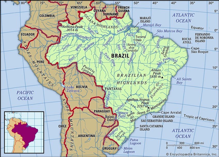
Location & Extent:
The Brazilian Plateau (also known as Brazilian Highlands) is located in central and eastern Brazil.
It spreads across several states including Minas Gerais, Goiás, Mato Grosso, São Paulo, and Bahia.
Covers nearly 5 million sq. km, comprising over half of Brazil’s total land area.
Physiography:
It is a vast ancient shield region, composed mainly of igneous and metamorphic rocks.
The terrain is undulating with elevations between 300 to 1,500 meters.
The plateau is divided into:
Central Plateau – broad, open highland terrain.
Southern Plateau – features basaltic lava flows, forming the Paraná Basin.
Eastern Plateau – highly dissected, source of many important rivers.
Rivers & Drainage:
Exhibits a radial drainage pattern due to its domed structure.
Major rivers include São Francisco, Paraná, Tocantins, and tributaries of the Amazon.
The Iguaçu Falls on the Paraná River is a notable feature on the plateau’s border with Argentina.
Soil & Vegetation:
Dominated by lateritic and red soils (ferralsols), rich in iron and aluminium but low in fertility.
Vegetation includes Cerrado (tropical savanna) in central areas and Caatinga (semi-arid scrubland) in the northeast.
Southern parts have fertile basaltic soils, ideal for farming.
Climate:
Experiences tropical savanna (Aw) climate in most parts.
Semi-arid in the northeast, particularly the Caatinga zone.
Humid subtropical climate prevails in southern regions.
Economic Importance:
Rivers provide high hydroelectric power potential – the Itaipu Dam is one of the largest in the world.
Significance:
Acts as a major watershed, separating rivers flowing to the Atlantic Ocean and the Amazon Basin.
Central to Brazil’s economic growth, through farming, mining, and energy production.
Influences population distribution, with cities like Brasília built on the plateau for strategic planning and development.
ब्राज़ील का पठार
स्थिति और विस्तार:
ब्राज़ील पठार (जिसे Brazilian Highlands भी कहते हैं) मध्य और पूर्वी ब्राज़ील में स्थित है।
यह कई राज्यों में फैला है, जिनमें मिनास गेरैस, गोईआस, मातो ग्रोसो, साओ पाउलो और बाहिया शामिल हैं।
यह लगभग 50 लाख वर्ग किलोमीटर में फैला हुआ है, जो ब्राज़ील के कुल क्षेत्रफल का आधे से अधिक है।
भूआकृति:
यह एक प्राचीन ढाल क्षेत्र है, जो मुख्यतः आग्नेय और रूपांतरित चट्टानों से बना है।
इसका भू-भाग तरंगित है और ऊंचाई 300 से 1,500 मीटर के बीच है।
यह पठार तीन भागों में विभाजित है:
केंद्रीय पठार – विस्तृत, खुला उच्चभूमि क्षेत्र।
दक्षिणी पठार – इसमें पैराना बेसिन में बेसाल्टिक लावा प्रवाह मिलते हैं।
पूर्वी पठार – अत्यधिक कटा हुआ क्षेत्र, जहां से कई प्रमुख नदियाँ निकलती हैं।
नदियाँ और जलनिकासी:
इसकी आकृति गुंबद जैसी होने के कारण इसमें रैडियल जलनिकासी पैटर्न देखा जाता है।
प्रमुख नदियाँ हैं – साओ फ्रांसिस्को, पैराना, टोकांटिन्स, और अमेज़न की सहायक नदियाँ।
इगुआसू जलप्रपात, जो पैराना नदी पर स्थित है, ब्राज़ील और अर्जेंटीना की सीमा पर एक प्रमुख विशेषता है।
मृदा और वनस्पति:
यहां लेटराइट और लाल मृदा (फेरालसॉल) पाई जाती है, जो लोहे और एल्युमीनियम से समृद्ध होती है लेकिन उपजाऊ नहीं होती।
वनस्पति में केंद्रीय भागों में सेराडो (उष्णकटिबंधीय घासभूमि) और पूर्वोत्तर में काआतिंगा (अर्ध-शुष्क झाड़ी क्षेत्र) शामिल हैं।
दक्षिणी हिस्सों में उपजाऊ बेसाल्टिक मृदा पाई जाती है, जो कृषि के लिए आदर्श है।
जलवायु:
अधिकांश क्षेत्रों में उष्णकटिबंधीय सावन्ना (Aw) जलवायु पाई जाती है।
पूर्वोत्तर में यह अर्ध-शुष्क होती है, विशेष रूप से काआतिंगा क्षेत्र में।
दक्षिणी क्षेत्रों में आर्द्र उपोष्णकटिबंधीय जलवायु पाई जाती है।
आर्थिक महत्व:
इसकी नदियाँ अत्यधिक जलविद्युत उत्पादन क्षमता रखती हैं – इटाइपू बाँध दुनिया के सबसे बड़े बाँधों में से एक है।
महत्व:
यह एक प्रमुख जल-विभाजक का कार्य करता है, जो अटलांटिक महासागर और अमेज़न बेसिन की ओर बहने वाली नदियों को अलग करता है।
यह ब्राज़ील की आर्थिक प्रगति के लिए महत्वपूर्ण है, विशेषकर कृषि, खनन और ऊर्जा उत्पादन में।
यह जनसंख्या वितरण को प्रभावित करता है — ब्रासीलिया जैसे शहर इसी पठार पर रणनीतिक दृष्टि से बसाए गए हैं।

