
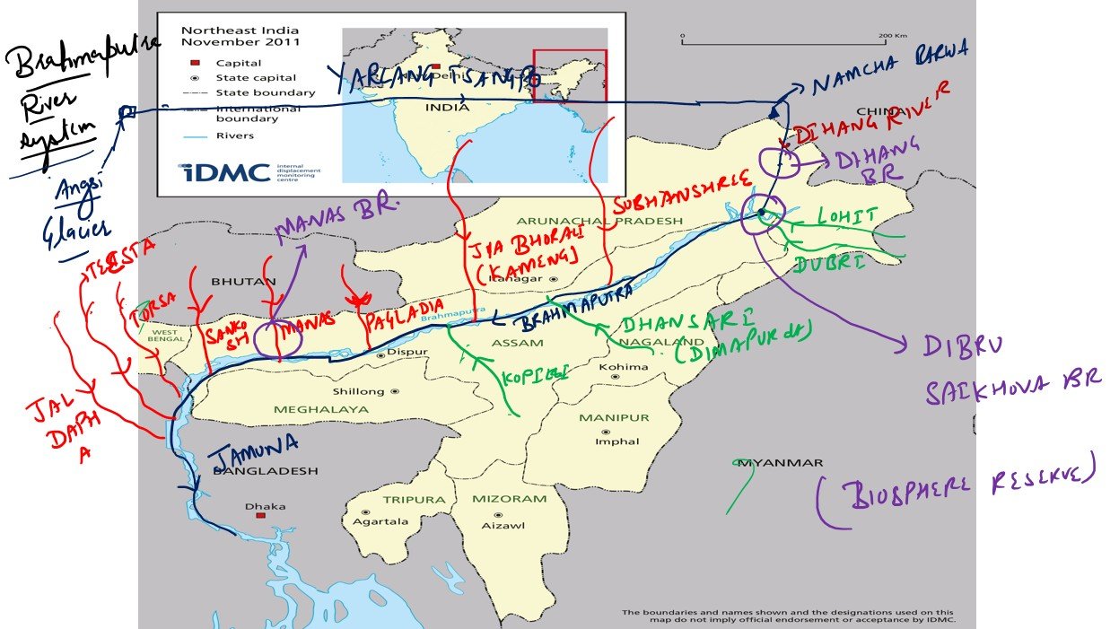
The Brahmaputra River has garnered attention due to concerns over China’s hydroelectric projects on the river.
Origin and Nomenclature:
The Brahmaputra River originates from the Chemayungdung Glacier in the Kailash range near Mansarovar Lake.
In Tibet, it is known as the Yarlung Tsangpo.
Upon entering India through Arunachal Pradesh, it is called the Siang or Dihang.
After merging with the Teesta River, it is known as the Jamuna in Bangladesh.
Course and Drainage:
The river enters India near Sadiya town in Arunachal Pradesh.
It flows through Arunachal Pradesh, Assam, and West Bengal, and into Bangladesh.
It eventually merges with the Ganga (called Padma in Bangladesh) near Goalundo Ghat.
The Padma joins the Meghna River and flows into the Bay of Bengal.
Length and Basin Coverage:
The total length of the Brahmaputra is 2,900 km, of which 916 km flows in India.
The drainage basin spans Tibet (China), Bhutan, India, and Bangladesh.
In India, it is bounded by the Himalayas (north & west), Patkai Hills (east), and Assam Hills (south).
Tributaries:
Right Bank Tributaries:
Lohit, Dibang, Subansiri, Jiabharali, Dhansiri, Manas, Torsa, Sankosh, Teesta.
Left Bank Tributaries:
Burhidihing, Desang, Dikhow, Dhansiri (South), Kopili.
Ecological Significance:
The Brahmaputra basin holds over 30% of India’s total water resources.
It contributes 41% to India’s hydropower potential.
The basin supports deciduous forests and major wildlife sanctuaries like Kaziranga and Manas.
Unique Geographical Features:
Majuli, the world’s largest river island, is located in the Brahmaputra.
Umananda, the smallest river island, is also located in the Brahmaputra in Assam.
India’s Role and Monitoring:
India contributes 80% of the Brahmaputra’s total flow, though it covers only 34% of the basin area.
This high flow is due to heavy rainfall (2,371 mm annually) and Himalayan snowmelt.
Tibet, by contrast, is a dry plateau with just 300 mm annual rainfall.
River-Linking Projects:
The Manas-Sankosh-Teesta-Ganga Link proposes to connect Brahmaputra’s tributaries with the Ganga to divert surplus water.
The Jogighopa-Teesta-Farakka Link aims to connect Jogighopa Barrage on Brahmaputra to Farakka Barrage on Ganga.
These projects are designed to mitigate water scarcity in drier regions and are unlikely to be affected by China’s upstream activities.
ब्रह्मपुत्र नदी प्रणाली
चीन की जलविद्युत परियोजनाओं को लेकर चिंताओं के कारण ब्रह्मपुत्र नदी ने ध्यान आकर्षित किया है।
उद्गम और नामकरण:
ब्रह्मपुत्र नदी का उद्गम कैलाश पर्वत श्रृंखला के चेमायुंदुंग ग्लेशियर से होता है, जो मानसरोवर झील के पास है।
तिब्बत में इसे यारलुंग त्सांगपो कहा जाता है।
अरुणाचल प्रदेश में प्रवेश करने पर इसे सियांग या दिहांग कहा जाता है।
बांग्लादेश में तीस्ता नदी से मिलने के बाद इसे जमुना कहा जाता है।
प्रवाह और अपवाह तंत्र:
यह नदी अरुणाचल प्रदेश के सादिया शहर के पास भारत में प्रवेश करती है।
यह अरुणाचल, असम, पश्चिम बंगाल होते हुए बांग्लादेश में बहती है।
गंगा (पद्मा) से गोलुंदो घाट (बांग्लादेश) में मिलती है।
पद्मा नदी आगे मेघना नदी से मिलकर बंगाल की खाड़ी में गिरती है।
लंबाई और बेसिन क्षेत्र:
ब्रह्मपुत्र की कुल लंबाई लगभग 2,900 किमी है, जिसमें से 916 किमी भारत में बहती है।
इसका अपवाह क्षेत्र तिब्बत (चीन), भूटान, भारत, और बांग्लादेश तक फैला है।
भारत में यह उत्तर और पश्चिम में हिमालय, पूर्व में पटकाई पहाड़ियां, और दक्षिण में असम की पहाड़ियां से घिरी है।
सहायक नदियाँ:
दाहिनी ओर की सहायक नदियाँ:
लोहित, दिबांग, सुबनसिरी, जियाभराली, धानसिरी, मानस, तोर्सा, संकोष, तीस्ता।
बाईं ओर की सहायक नदियाँ:
बुर्हीदिहिंग, देसांग, दिखो, धानसिरी (दक्षिण), कोपिली।
पर्यावरणीय महत्व:
ब्रह्मपुत्र बेसिन भारत के 30% जल संसाधनों को समाहित करता है।
यह भारत की 41% जलविद्युत क्षमता का स्रोत है।
इसके क्षेत्र में पर्णपाती वन, काज़ीरंगा और मानस जैसे प्रमुख वन्यजीव अभयारण्य हैं।
भौगोलिक विशेषताएँ:
माजुली, दुनिया का सबसे बड़ा नदी द्वीप, ब्रह्मपुत्र में स्थित है।
उमानंदा, दुनिया का सबसे छोटा नदी द्वीप, भी असम में ब्रह्मपुत्र में स्थित है।
भारत की भूमिका और निगरानी:
भारत केवल 34% बेसिन क्षेत्र कवर करता है, लेकिन 80% जल प्रवाह प्रदान करता है।
इसका कारण है अत्यधिक वर्षा (2,371 मिमी) और हिमपात पिघलाव, जबकि तिब्बत में 300 मिमी वार्षिक वर्षा होती है।
भारत में मौजूद सहायक नदियाँ जल प्रवाह को और भी बढ़ाती हैं।
नदी जोड़ परियोजनाएँ:
मानस-संकोष-तीस्ता-गंगा लिंक परियोजना ब्रह्मपुत्र की सहायक नदियों से गंगा तक जल स्थानांतरण का प्रस्ताव देती है।
जोगीघोपा-तीस्ता-फारक्का लिंक ब्रह्मपुत्र को फारक्का बैराज से जोड़ने की योजना है।
ये परियोजनाएँ सूखे क्षेत्रों को पानी उपलब्ध कराने हेतु हैं और चीन की गतिविधियों से प्रभावित नहीं होंगी।

 Mon - Fri: 09:00 - 20:00 Sat & Sun : 10:30 - 18:00

