Skip links

Gulf of Khambhat

Gulf of Khambhat


Location & Geography:
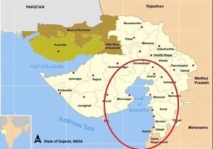
The Gulf of Khambhat, formerly known as the Gulf of Cambay, is a funnel-shaped inlet of the Arabian Sea located on the western coast of India in the state of Gujarat.
It lies between the Kathiawar Peninsula on the west and mainland Gujarat on the east, stretching about 130 km in length.
The Gulf is known for having one of India’s highest tidal ranges, with tides reaching up to 11 meters, creating strong tidal currents.
It is part of the Cambay Basin, a significant geological rift basin formed due to tectonic activity.
Rivers & Hydrology:
Major rivers flowing into the Gulf include: Narmada, Tapi, Mahi, Sabarmati
These rivers bring nutrient-rich sediments, supporting mangrove growth, fisheries, and rich biodiversity in the estuarine ecosystem.
The high freshwater inflow combined with tidal action creates unique estuarine habitats.
Ecological & Environmental Importance:
The Gulf supports dense mangrove forests, predominantly Avicennia marina, alongside Ceriops tagal and Rhizophora mucronata.
Its intertidal mudflats, estuaries, and creeks sustain diverse flora and fauna, including migratory birds like flamingos, egrets, herons, and juvenile fish species.
Mangroves act as natural coastal protectors against erosion, cyclones, and tidal surges.
The Gulf serves as a vital carbon sink and contributes to microclimate regulation.
Economic Importance:
The Gulf region houses several important ports such as Dahej, Hazira, Bharuch, and Bhavnagar, which are crucial for maritime trade and industry.
The area supports significant marine fisheries, salt production, shipbuilding, and petrochemical industries.
The Cambay Basin is rich in oil and natural gas reserves, making it an important energy-producing region for India.
The Sagarmala Project and National Blue Economy initiatives focus on developing port infrastructure and boosting coastal economy here.
Historical & Archaeological Significance:
The nearby ancient port city of Lothal on the Bhogava River was a prominent Indus Valley Civilization site and one of the world’s earliest known dockyards, highlighting the region’s ancient maritime importance.
Recent underwater explorations have suggested the presence of submerged ancient settlements in the Gulf, though findings remain debated.
Strategic Importance:
The Gulf’s location near key shipping lanes in the Arabian Sea and proximity to the Gulf of Oman makes it strategically vital for India’s maritime security and trade routes.
Expansion of ports like Dahej and Hazira enhances Gujarat’s role as a maritime hub.

खंभात की खाड़ी
स्थान और भौगोलिक स्थिति:
गुल्फ ऑफ खंभात, जिसे पहले गुल्फ ऑफ कैमबे कहा जाता था, भारत के पश्चिमी तट पर गुजरात राज्य में स्थित है।
यह काठियावाड़ प्रायद्वीप के पूर्व और गुजरात के मुख्यभूमि के बीच स्थित एक अरेबियन सागर की खाड़ी है।
यह लगभग 130 किलोमीटर लंबी है और इसकी आकृति फ़नल (शंख) जैसी होती है, जो भीतर की ओर संकुचित होती है।
यहां भारत की सबसे उच्च ज्वार-भाटा होती है, जिसकी ऊंचाई लगभग 11 मीटर तक पहुँचती है।
यह खाड़ी कैम्बे बेसिन का हिस्सा है, जो एक महत्वपूर्ण टेक्टोनिक विस्थापन (भूकंपीय) क्षेत्र है।
नदियाँ और जलविद्युत:
खाड़ी में गिरने वाली प्रमुख नदियाँ हैं: नर्मदा, ताप्ती, माही, साबरमती
ये नदियाँ खाद्य तत्वों से भरपूर तलछट लाती हैं, जो मैंग्रोव वनस्पतियों और मछली पालन के लिए उपयुक्त वातावरण प्रदान करती हैं।
नदी और ज्वार-भाटा के संयोजन से यहाँ विशिष्ट मुहाना (एस्टुअरी) और दलदलीय इलाके बनते हैं।
पारिस्थितिकी और पर्यावरणीय महत्व:
खाड़ी के आसपास गाढ़े मैंग्रोव वन पाए जाते हैं, जिनमें मुख्य रूप से एविसेन्निया मारिना, सेरिओप्स टैगल, और राइज़ोफ़ोरा म्यूक्रोनेटा शामिल हैं।
यहाँ की ज्वारीय दलदल, मुहाने और नालों में विविध वनस्पति और जीव-जंतु पाए जाते हैं, जिनमें प्रवासी पक्षी जैसे फ्लेमिंगो, बगुले, सारस पक्षी और किंगफिशर शामिल हैं।
मैंग्रोव वन तटीय क्षेत्रों को तूफान, समुद्री ज्वार-भाटा और कटाव से सुरक्षा प्रदान करते हैं।
यह क्षेत्र कार्बन सिंक के रूप में कार्य करता है और स्थानीय जलवायु को नियंत्रित करता है।
आर्थिक महत्व:
खाड़ी क्षेत्र में कई महत्वपूर्ण बंदरगाह स्थित हैं, जैसे: दहेज, हजिरा, भरूच, भावनगर
ये बंदरगाह समुद्री व्यापार और औद्योगिक विकास के लिए महत्वपूर्ण हैं।
क्षेत्र में मछली पालन, नमक उत्पादन, जहाज निर्माण, और पेट्रोकेमिकल उद्योग विकसित हैं।
कैम्बे बेसिन में तेल और प्राकृतिक गैस के बड़े भंडार पाए जाते हैं, जो भारत की ऊर्जा आवश्यकताओं में योगदान करते हैं।
सागरमाला परियोजना और नीली अर्थव्यवस्था (Blue Economy) के अंतर्गत बंदरगाहों के विकास को बढ़ावा दिया जा रहा है।
ऐतिहासिक और पुरातात्विक महत्व:
खाड़ी के निकट लोथल नामक स्थल है, जो सिंधु घाटी सभ्यता का एक प्राचीन बंदरगाह शहर था।
लोथल दुनिया के प्राचीनतम डॉकयार्ड्स (जहाज घाट) में से एक माना जाता है, जो समुद्री व्यापार का केंद्र था।
हाल ही में खाड़ी में कुछ डूबे हुए प्राचीन शहरों के अवशेष मिलने का दावा किया गया है, हालांकि ये शोध विवादित हैं।
रणनीतिक महत्व:
खाड़ी की स्थिति अरेबियन सागर और ओमान की खाड़ी के महत्वपूर्ण समुद्री मार्गों के नजदीक है, जो भारत के समुद्री सुरक्षा और व्यापार के लिए रणनीतिक रूप से महत्वपूर्ण है।
दहेज और हजिरा जैसे बंदरगाहों का विकास गुजरात को एक प्रमुख समुद्री केंद्र बना रहा है।